Lake Winnebago geodata
Lake Winnebago (Missouri) is a populated place; located in United States in America/Chicago (GMT-5) time zone. With population of 1,144 people, there are 15417 cities with bigger population in this country. Compared to other cities in United States, 56.3% of cities are located further ↑North; 69.5% of cities are located further →East and 72.4% of cities have lower elevation than Lake Winnebago. Note1


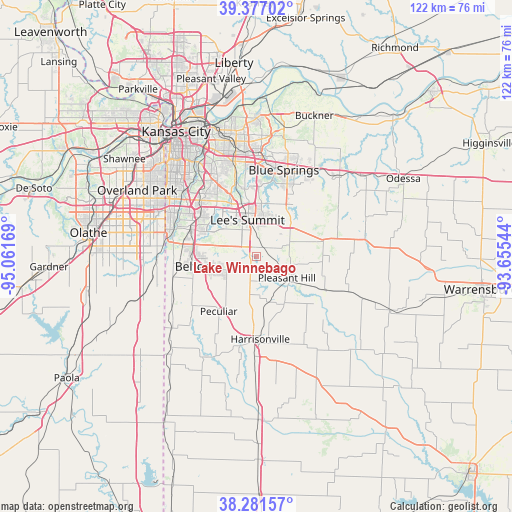
Lake Winnebago GPS coordinates[2]
38° 49' 53.04" North, 94° 21' 30.816" West
| Map corner | latitude | longitude |
|---|---|---|
| Upper-left | 39.37702°, | -95.06169° |
| Center: | 38.8314°, | -94.35856° |
| Lower-right: | 38.28157°, | -93.65544° |
| Map W x H: | 121.8×121.8 km | = 75.7×75.7mi |
| max Lat: | 71.29058° ⇑56.3% North |
| Lake Winnebago: | 38.8314° |
| min Lat: | ⇓43.7% South 19.06759° |
| min Long | Lake Winnebago | max Long |
| -171.73463° | -94.35856° | -66.98998° |
| W 30.5%⇐ | ⇒69.5% E |
Elevation
Elevation of Lake Winnebago is 298 m = 978 ft, and this is 3.2 m = 10 ft above average elevation for this country.
| Max E: |
3189 m = 10463 ft | 27.6% |
| Lake Winnebago | 298 m 978 ft | |
| Avg. | 294.8 m = 967 ft | |
Min E: |
-60 m = -197 ft | 72.4% |
See also: United States elevation on elevation.city.
Geographical zone
Lake Winnebago is located in North temperate zone (between Tropic of Cancer and the Arctic Circle). Distance of this Northern Tropic circle is 1711.7 km =1063.6 mi to South.| Distance of | km | miles | from Lake Winnebago |
|---|---|---|---|
| North Pole | 5689.4 | 3535.2 | to North |
| Arctic Circle | 3083.5 | 1916 | to North |
| Tropic Cancer | 1711.7 | 1063.6 | to South |
| Equator | 4317.6 | 2682.8 | to South |


Nearby cities:
15 places around Lake Winnebago: (largest is in red/bold)
• Belton
15.2 km =9.4 mi,  261°
261°
• Blue Springs
21.7 km =13.5 mi,  17°
17°
• Grain Valley
24.7 km =15.3 mi,  34°
34°
• Grandview
16.3 km =10.1 mi,  291°
291°
• Greenwood
2.6 km =1.6 mi, 29°
• Harrisonville
19.8 km =12.3 mi,  177°
177°
• Lake Lotawana
14.2 km =8.8 mi,  44°
44°
• Lake Tapawingo
21.5 km =13.4 mi,  10°
10°
• Lee's Summit
9.1 km =5.7 mi,  346°
346°
• Loch Lloyd
20.7 km =12.9 mi,  269°
269°
• Lone Jack
16.6 km =10.3 mi,  74°
74°
• Peculiar
15.2 km =9.4 mi,  214°
214°
• Pleasant Hill
9.1 km =5.7 mi,  122°
122°
• Raymore
8.8 km =5.5 mi,  248°
248°
• Raytown
21.7 km =13.5 mi,  335°
335°
Sources, notices
• [Note1] Compared only with cities in United States existing in our database
• [Src1] Map data: © OpenStreetMap contributors (CC-BY-SA)
• [Src2] Other city data from geonames.org with taken over terms of usage.
• [Src3] Geographical zone / Annual Mean Temperature by Robert A. Rohde @ Wikipedia
