Pleasant Valley geodata
Pleasant Valley (Missouri) is a populated place; located in United States in America/Chicago (GMT-5) time zone. With population of 3,056 people, there are 9543 cities with bigger population in this country. Compared to other cities in United States, 52.9% of cities are located further ↑North; 69.9% of cities are located further →East and 61% of cities have lower elevation than Pleasant Valley. Note1


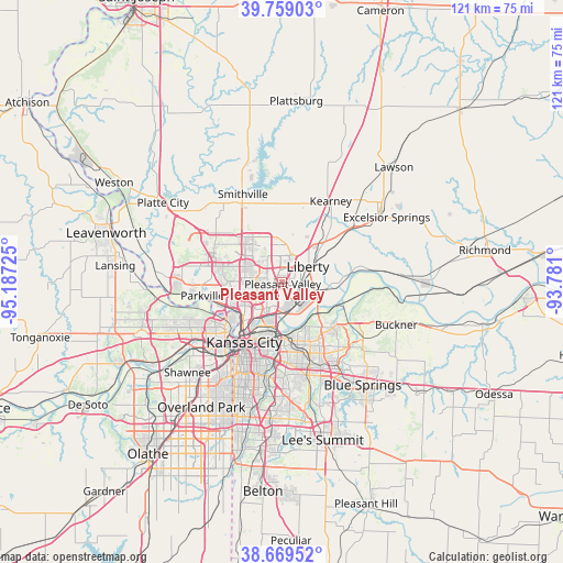
Pleasant Valley GPS coordinates[2]
39° 12' 59.004" North, 94° 29' 2.832" West
| Map corner | latitude | longitude |
|---|---|---|
| Upper-left | 39.75903°, | -95.18725° |
| Center: | 39.21639°, | -94.48412° |
| Lower-right: | 38.66952°, | -93.781° |
| Map W x H: | 121.1×121.1 km | = 75.2×75.2mi |
| max Lat: | 71.29058° ⇑52.9% North |
| Pleasant Valley: | 39.21639° |
| min Lat: | ⇓47.1% South 19.06759° |
| min Long | Pleasant Valley | max Long |
| -171.73463° | -94.48412° | -66.98998° |
| W 30.1%⇐ | ⇒69.9% E |
Elevation
Elevation of Pleasant Valley is 244 m = 801 ft, and this is 50.8 m = 167 ft below average elevation for this country.
| Max E: |
3189 m = 10463 ft | 39% |
| Avg. | 294.8 m = 967 ft | |
| Pleasant Valley | 244 m = 801 ft | |
Min E: |
-60 m = -197 ft | 61% |
See also: United States elevation on elevation.city.
Geographical zone
Pleasant Valley is located in North temperate zone (between Tropic of Cancer and the Arctic Circle). Distance of this Northern Tropic circle is 1754.5 km =1090.2 mi to South.| Distance of | km | miles | from Pleasant Valley |
|---|---|---|---|
| North Pole | 5646.6 | 3508.6 | to North |
| Arctic Circle | 3040.7 | 1889.4 | to North |
| Tropic Cancer | 1754.5 | 1090.2 | to South |
| Equator | 4360.5 | 2709.5 | to South |


Nearby cities:
15 places around Pleasant Valley: (largest is in red/bold)
• Claycomo
1.7 km =1.1 mi,  204°
204°
• East Independence
17.4 km =10.8 mi,  140°
140°
• Gladstone
6.2 km =3.9 mi,  257°
257°
• Glenaire
2.9 km =1.8 mi,  78°
78°
• Independence
15.1 km =9.4 mi,  156°
156°
• Kansas City
15.3 km =9.5 mi,  212°
212°
• Kansas City
16.8 km =10.4 mi,  227°
227°
• Kearney
19.8 km =12.3 mi,  31°
31°
• Lake Waukomis
13.4 km =8.3 mi,  277°
277°
• Liberty
6.5 km =4 mi,  59°
59°
• North Kansas City
11.7 km =7.3 mi,  215°
215°
• Parkville
17.2 km =10.7 mi, 262°
• Riverside
11.9 km =7.4 mi,  248°
248°
• Sugar Creek
12.3 km =7.6 mi, 163°
• Weatherby Lake
18.4 km =11.4 mi, 277°
Sources, notices
• [Note1] Compared only with cities in United States existing in our database
• [Src1] Map data: © OpenStreetMap contributors (CC-BY-SA)
• [Src2] Other city data from geonames.org with taken over terms of usage.
• [Src3] Geographical zone / Annual Mean Temperature by Robert A. Rohde @ Wikipedia
