Independence geodata
Independence (Missouri) is a populated place; located in United States in America/Chicago (GMT-5) time zone. With population of 117,255 people, there are 268 cities with bigger population in this country. Compared to other cities in United States, 54% of cities are located further ↑North; 69.7% of cities are located further →East and 75.8% of cities have lower elevation than Independence. Note1


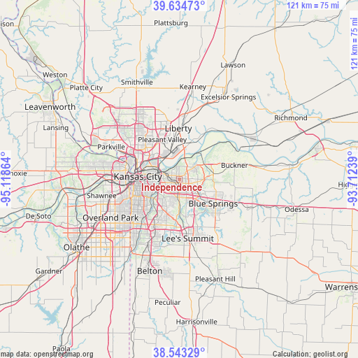
Independence GPS coordinates[2]
39° 5' 28.032" North, 94° 24' 55.836" West
| Map corner | latitude | longitude |
|---|---|---|
| Upper-left | 39.63473°, | -95.11864° |
| Center: | 39.09112°, | -94.41551° |
| Lower-right: | 38.54329°, | -93.71239° |
| Map W x H: | 121.4×121.4 km | = 75.4×75.4mi |
| max Lat: | 71.29058° ⇑54% North |
| Independence: | 39.09112° |
| min Lat: | ⇓46% South 19.06759° |
| min Long | Independence | max Long |
| -171.73463° | -94.41551° | -66.98998° |
| W 30.3%⇐ | ⇒69.7% E |
Elevation
Elevation of Independence is 319 m = 1047 ft, and this is 24.2 m = 79 ft above average elevation for this country.
| Max E: |
3189 m = 10463 ft | 24.2% |
| Independence | 319 m 1047 ft | |
| Avg. | 294.8 m = 967 ft | |
Min E: |
-60 m = -197 ft | 75.8% |
See also: Independence elevation on elevation.city.
Geographical zone
Independence is located in North temperate zone (between Tropic of Cancer and the Arctic Circle). Distance of this Northern Tropic circle is 1740.6 km =1081.6 mi to South.| Distance of | km | miles | from Independence |
|---|---|---|---|
| North Pole | 5660.5 | 3517.3 | to North |
| Arctic Circle | 3054.6 | 1898 | to North |
| Tropic Cancer | 1740.6 | 1081.6 | to South |
| Equator | 4346.5 | 2700.8 | to South |


Nearby cities:
15 places around Independence: (largest is in red/bold)
• Blue Springs
14.2 km =8.8 mi,  125°
125°
• Claycomo
14 km =8.7 mi,  331°
331°
• East Independence
5.2 km =3.2 mi,  84°
84°
• Gladstone
17.4 km =10.8 mi,  316°
316°
• Glenaire
14.8 km =9.2 mi,  347°
347°
• Kansas City
14.1 km =8.8 mi,  273°
273°
• Kansas City
18.5 km =11.5 mi,  277°
277°
• Lake Tapawingo
11.9 km =7.4 mi, 130°
• Liberty
17.2 km =10.7 mi,  358°
358°
• Mission Hills
19.2 km =11.9 mi,  244°
244°
• North Kansas City
13.4 km =8.3 mi,  288°
288°
• Pleasant Valley
15.1 km =9.4 mi,  336°
336°
• Raytown
10.1 km =6.3 mi,  204°
204°
• Sugar Creek
3.3 km =2.1 mi,  309°
309°
• Westwood
18.3 km =11.4 mi,  252°
252°
Sources, notices
• [Note1] Compared only with cities in United States existing in our database
• [Src1] Map data: © OpenStreetMap contributors (CC-BY-SA)
• [Src2] Other city data from geonames.org with taken over terms of usage.
• [Src3] Geographical zone / Annual Mean Temperature by Robert A. Rohde @ Wikipedia
