Raytown geodata
Raytown (Missouri) is a populated place; located in United States in America/Chicago (GMT-5) time zone. With population of 29,401 people, there are 1696 cities with bigger population in this country. Compared to other cities in United States, 54.8% of cities are located further ↑North; 69.8% of cities are located further →East and 74.5% of cities have lower elevation than Raytown. Note1


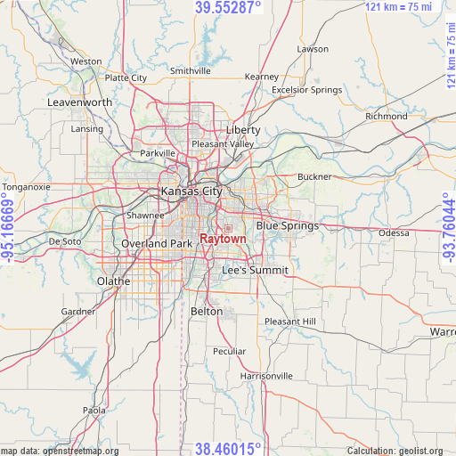
Raytown GPS coordinates[2]
39° 0' 31.032" North, 94° 27' 48.816" West
| Map corner | latitude | longitude |
|---|---|---|
| Upper-left | 39.55287°, | -95.16669° |
| Center: | 39.00862°, | -94.46356° |
| Lower-right: | 38.46015°, | -93.76044° |
| Map W x H: | 121.5×121.5 km | = 75.5×75.5mi |
| max Lat: | 71.29058° ⇑54.8% North |
| Raytown: | 39.00862° |
| min Lat: | ⇓45.2% South 19.06759° |
| min Long | Raytown | max Long |
| -171.73463° | -94.46356° | -66.98998° |
| W 30.2%⇐ | ⇒69.8% E |
Elevation
Elevation of Raytown is 310 m = 1017 ft, and this is 15.2 m = 50 ft above average elevation for this country.
| Max E: |
3189 m = 10463 ft | 25.5% |
| Raytown | 310 m 1017 ft | |
| Avg. | 294.8 m = 967 ft | |
Min E: |
-60 m = -197 ft | 74.5% |
See also: United States elevation on elevation.city.
Geographical zone
Raytown is located in North temperate zone (between Tropic of Cancer and the Arctic Circle). Distance of this Northern Tropic circle is 1731.4 km =1075.8 mi to South.| Distance of | km | miles | from Raytown |
|---|---|---|---|
| North Pole | 5669.7 | 3523 | to North |
| Arctic Circle | 3063.8 | 1903.8 | to North |
| Tropic Cancer | 1731.4 | 1075.8 | to South |
| Equator | 4337.4 | 2695.1 | to South |


Nearby cities:
15 places around Raytown: (largest is in red/bold)
• Blue Springs
15.7 km =9.8 mi,  86°
86°
• East Independence
13.5 km =8.4 mi,  44°
44°
• Fairway
14.6 km =9.1 mi,  275°
275°
• Grandview
14.9 km =9.3 mi,  203°
203°
• Independence
10.1 km =6.3 mi,  24°
24°
• Kansas City
14.2 km =8.8 mi,  315°
315°
• Lake Tapawingo
13.2 km =8.2 mi,  83°
83°
• Leawood
14 km =8.7 mi,  250°
250°
• Lee's Summit
13 km =8.1 mi,  147°
147°
• Mission Hills
13.3 km =8.3 mi,  274°
274°
• North Kansas City
16 km =9.9 mi,  327°
327°
• Prairie Village
14.8 km =9.2 mi,  262°
262°
• Roeland Park
14.9 km =9.3 mi, 282°
• Sugar Creek
11.4 km =7.1 mi,  8°
8°
• Westwood
13.7 km =8.5 mi,  285°
285°
Sources, notices
• [Note1] Compared only with cities in United States existing in our database
• [Src1] Map data: © OpenStreetMap contributors (CC-BY-SA)
• [Src2] Other city data from geonames.org with taken over terms of usage.
• [Src3] Geographical zone / Annual Mean Temperature by Robert A. Rohde @ Wikipedia
