Denver geodata
Denver (North Carolina) is a populated place; located in United States in America/New_York (GMT-4) time zone. With population of 2,309 people, there are 11060 cities with bigger population in this country. Compared to other cities in United States, 72.5% of cities are located further ↑North; 69.4% of cities are located further ←West and 68% of cities have lower elevation than Denver. Note1
Administrative division(s):
- Level 1: North Carolina
- Level 2: Lincoln County
- Level 3: Township of Catawba Springs


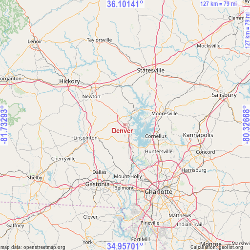
Denver GPS coordinates[2]
35° 31' 52.5" North, 81° 1' 47.28" West
| Map corner | latitude | longitude |
|---|---|---|
| Upper-left | 36.10141°, | -81.73293° |
| Center: | 35.53125°, | -81.0298° |
| Lower-right: | 34.95701°, | -80.32668° |
| Map W x H: | 127.2×127.2 km | = 79×79mi |
| max Lat: | 71.29058° ⇑72.5% North |
| Denver: | 35.53125° |
| min Lat: | ⇓27.5% South 19.06759° |
| min Long | Denver | max Long |
| -171.73463° | -81.0298° | -66.98998° |
| W 69.4%⇐ | ⇒30.6% E |
Elevation
Elevation of Denver is 276 m = 906 ft, and this is 18.8 m = 62 ft below average elevation for this country.
| Max E: |
3189 m = 10463 ft | 32% |
| Avg. | 294.8 m = 967 ft | |
| Denver | 276 m = 906 ft | |
Min E: |
-60 m = -197 ft | 68% |
See also: United States elevation on elevation.city.
Geographical zone
Denver is located in North temperate zone (between Tropic of Cancer and the Arctic Circle). Distance of this Northern Tropic circle is 1344.8 km =835.6 mi to South.| Distance of | km | miles | from Denver |
|---|---|---|---|
| North Pole | 6056.4 | 3763.3 | to North |
| Arctic Circle | 3450.5 | 2144 | to North |
| Tropic Cancer | 1344.8 | 835.6 | to South |
| Equator | 3950.7 | 2454.9 | to South |


Nearby cities:
15 places around Denver: (largest is in red/bold)
• Boger City
17.5 km =10.9 mi,  251°
251°
• Catawba
20 km =12.4 mi,  348°
348°
• Cornelius
16.1 km =10 mi,  107°
107°
• Davidson
17.6 km =10.9 mi,  100°
100°
• High Shoals
21.2 km =13.2 mi,  227°
227°
• Iron Station
15.2 km =9.4 mi, 228°
• Lake Norman of Catawba
8.9 km =5.5 mi,  45°
45°
• Lincolnton
21.3 km =13.2 mi, 252°
• Lowesville
12.8 km =8 mi,  172°
172°
• Maiden
17.2 km =10.7 mi,  286°
286°
• Mooresville
20.8 km =12.9 mi,  73°
73°
• Pumpkin Center
10.2 km =6.3 mi,  262°
262°
• Sherrills Ford
10.7 km =6.6 mi,  21°
21°
• Stanley
20.1 km =12.5 mi,  197°
197°
• Westport
5.7 km =3.5 mi,  125°
125°
Sources, notices
• [Note1] Compared only with cities in United States existing in our database
• [Src1] Map data: © OpenStreetMap contributors (CC-BY-SA)
• [Src2] Other city data from geonames.org with taken over terms of usage.
• [Src3] Geographical zone / Annual Mean Temperature by Robert A. Rohde @ Wikipedia
