Mooresville geodata
Mooresville (North Carolina) is a populated place; located in United States in America/New_York (GMT-4) time zone. With population of 36,009 people, there are 1362 cities with bigger population in this country. Compared to other cities in United States, 72.3% of cities are located further ↑North; 69.9% of cities are located further ←West and 68% of cities have lower elevation than Mooresville. Note1
Administrative division(s):
- Level 1: North Carolina
- Level 2: Iredell County
- Level 3: Township of Coddle Creek


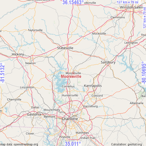
Mooresville GPS coordinates[2]
35° 35' 5.496" North, 80° 48' 36.252" West
| Map corner | latitude | longitude |
|---|---|---|
| Upper-left | 36.15463°, | -81.5132° |
| Center: | 35.58486°, | -80.81007° |
| Lower-right: | 35.011°, | -80.10695° |
| Map W x H: | 127.2×127.2 km | = 79×79mi |
| max Lat: | 71.29058° ⇑72.3% North |
| Mooresville: | 35.58486° |
| min Lat: | ⇓27.7% South 19.06759° |
| min Long | Mooresville | max Long |
| -171.73463° | -80.81007° | -66.98998° |
| W 69.9%⇐ | ⇒30.1% E |
Elevation
Elevation of Mooresville is 276 m = 906 ft, and this is 18.8 m = 62 ft below average elevation for this country.
| Max E: |
3189 m = 10463 ft | 32% |
| Avg. | 294.8 m = 967 ft | |
| Mooresville | 276 m = 906 ft | |
Min E: |
-60 m = -197 ft | 68% |
See also: United States elevation on elevation.city.
Geographical zone
Mooresville is located in North temperate zone (between Tropic of Cancer and the Arctic Circle). Distance of this Northern Tropic circle is 1350.7 km =839.3 mi to South.| Distance of | km | miles | from Mooresville |
|---|---|---|---|
| North Pole | 6050.4 | 3759.5 | to North |
| Arctic Circle | 3444.5 | 2140.3 | to North |
| Tropic Cancer | 1350.7 | 839.3 | to South |
| Equator | 3956.7 | 2458.6 | to South |


Nearby cities:
15 places around Mooresville: (largest is in red/bold)
• China Grove
20.7 km =12.9 mi,  94°
94°
• Cleveland
20.4 km =12.7 mi,  36°
36°
• Cornelius
11.8 km =7.3 mi,  202°
202°
• Davidson
9.5 km =5.9 mi, 195°
• Denver
20.8 km =12.9 mi,  253°
253°
• Enochville
14.2 km =8.8 mi,  115°
115°
• Huntersville
19.6 km =12.2 mi,  188°
188°
• Kannapolis
20.2 km =12.6 mi, 122°
• Lake Norman of Catawba
13.5 km =8.4 mi,  270°
270°
• Landis
18.5 km =11.5 mi,  103°
103°
• Lowesville
26.1 km =16.2 mi,  224°
224°
• Sherrills Ford
16.4 km =10.2 mi,  283°
283°
• Statesville
23.1 km =14.4 mi,  342°
342°
• Troutman
14.7 km =9.1 mi,  331°
331°
• Westport
17.9 km =11.1 mi,  238°
238°
Sources, notices
• [Note1] Compared only with cities in United States existing in our database
• [Src1] Map data: © OpenStreetMap contributors (CC-BY-SA)
• [Src2] Other city data from geonames.org with taken over terms of usage.
• [Src3] Geographical zone / Annual Mean Temperature by Robert A. Rohde @ Wikipedia
