Hampstead geodata
Hampstead (North Carolina) is a populated place; located in United States in America/New_York (GMT-4) time zone. With population of 4,083 people, there are 8120 cities with bigger population in this country. Compared to other cities in United States, 78.2% of cities are located further ↑North; 78.4% of cities are located further ←West and 94.8% of cities have higher elevation than Hampstead. Note1
Administrative division(s):
- Level 1: North Carolina
- Level 2: Pender County
- Level 3: Township of Topsail


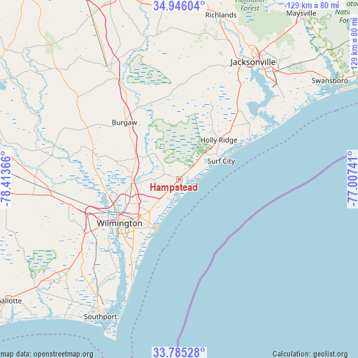
Hampstead GPS coordinates[2]
34° 22' 3.612" North, 77° 42' 37.908" West
| Map corner | latitude | longitude |
|---|---|---|
| Upper-left | 34.94604°, | -78.41366° |
| Center: | 34.36767°, | -77.71053° |
| Lower-right: | 33.78528°, | -77.00741° |
| Map W x H: | 129.1×129.1 km | = 80.2×80.2mi |
| max Lat: | 71.29058° ⇑78.2% North |
| Hampstead: | 34.36767° |
| min Lat: | ⇓21.8% South 19.06759° |
| min Long | Hampstead | max Long |
| -171.73463° | -77.71053° | -66.98998° |
| W 78.4%⇐ | ⇒21.6% E |
Elevation
Elevation of Hampstead is 9 m = 30 ft, and this is 285.8 m = 938 ft below average elevation for this country.
| Max E: |
3189 m = 10463 ft | 94.8% |
| Avg. | 294.8 m = 967 ft | |
| Hampstead | 9 m = 30 ft | |
Min E: |
-60 m = -197 ft | 5.2% |
See also: United States elevation on elevation.city.
Geographical zone
Hampstead is located in North temperate zone (between Tropic of Cancer and the Arctic Circle). Distance of this Northern Tropic circle is 1215.4 km =755.2 mi to South.| Distance of | km | miles | from Hampstead |
|---|---|---|---|
| North Pole | 6185.7 | 3843.6 | to North |
| Arctic Circle | 3579.8 | 2224.4 | to North |
| Tropic Cancer | 1215.4 | 755.2 | to South |
| Equator | 3821.3 | 2374.4 | to South |


Nearby cities:
15 places around Hampstead: (largest is in red/bold)
• Bayshore
11.2 km =7 mi,  219°
219°
• Castle Hayne
17.4 km =10.8 mi,  265°
265°
• Hightsville
23 km =14.3 mi,  241°
241°
• Holly Ridge
20.1 km =12.5 mi,  45°
45°
• Kings Grant
18.3 km =11.4 mi,  230°
230°
• Kirkland
10.3 km =6.4 mi, 223°
• Murraysville
14.9 km =9.3 mi, 237°
• Northchase
16.7 km =10.4 mi,  246°
246°
• Ogden
14.5 km =9 mi, 223°
• Rocky Point
17.9 km =11.1 mi,  294°
294°
• Seagate
21.4 km =13.3 mi,  214°
214°
• Skippers Corner
17.8 km =11.1 mi,  262°
262°
• Surf City
16.5 km =10.3 mi,  66°
66°
• Wrightsboro
21.2 km =13.2 mi, 245°
• Wrightsville Beach
19.4 km =12.1 mi,  204°
204°
Sources, notices
• [Note1] Compared only with cities in United States existing in our database
• [Src1] Map data: © OpenStreetMap contributors (CC-BY-SA)
• [Src2] Other city data from geonames.org with taken over terms of usage.
• [Src3] Geographical zone / Annual Mean Temperature by Robert A. Rohde @ Wikipedia
