Skippers Corner geodata
Skippers Corner (North Carolina) is a populated place; located in United States in America/New_York (GMT-4) time zone. With population of 2,785 people, there are 10016 cities with bigger population in this country. Compared to other cities in United States, 78.3% of cities are located further ↑North; 78% of cities are located further ←West and 96.6% of cities have higher elevation than Skippers Corner. Note1
Administrative division(s):
- Level 1: North Carolina
- Level 2: New Hanover County
- Level 3: Township of Cape Fear


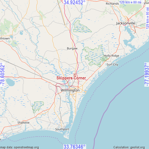
Skippers Corner GPS coordinates[2]
34° 20' 45.6" North, 77° 54' 8.964" West
| Map corner | latitude | longitude |
|---|---|---|
| Upper-left | 34.92452°, | -78.60562° |
| Center: | 34.346°, | -77.90249° |
| Lower-right: | 33.76346°, | -77.19937° |
| Map W x H: | 129.1×129.1 km | = 80.2×80.2mi |
| max Lat: | 71.29058° ⇑78.3% North |
| Skippers Corner: | 34.346° |
| min Lat: | ⇓21.7% South 19.06759° |
| min Long | Skippers Corner | max Long |
| -171.73463° | -77.90249° | -66.98998° |
| W 78%⇐ | ⇒22% E |
Elevation
Elevation of Skippers Corner is 7 m = 23 ft, and this is 287.8 m = 944 ft below average elevation for this country.
| Max E: |
3189 m = 10463 ft | 96.6% |
| Avg. | 294.8 m = 967 ft | |
| Skippers Corner | 7 m = 23 ft | |
Min E: |
-60 m = -197 ft | 3.4% |
See also: United States elevation on elevation.city.
Geographical zone
Skippers Corner is located in North temperate zone (between Tropic of Cancer and the Arctic Circle). Distance of this Northern Tropic circle is 1213 km =753.7 mi to South.| Distance of | km | miles | from Skippers Corner |
|---|---|---|---|
| North Pole | 6188.1 | 3845.1 | to North |
| Arctic Circle | 3582.3 | 2225.9 | to North |
| Tropic Cancer | 1213 | 753.7 | to South |
| Equator | 3818.9 | 2373 | to South |


Nearby cities:
15 places around Skippers Corner: (largest is in red/bold)
• Bayshore
12.3 km =7.6 mi,  120°
120°
• Belville
14.1 km =8.8 mi,  204°
204°
• Castle Hayne
1.1 km =0.7 mi,  11°
11°
• Hightsville
8.9 km =5.5 mi, 197°
• Kings Grant
9.9 km =6.2 mi,  158°
158°
• Kirkland
11.7 km =7.3 mi, 115°
• Leland
16.4 km =10.2 mi,  232°
232°
• Murraysville
7.5 km =4.7 mi,  137°
137°
• Navassa
13.9 km =8.6 mi,  223°
223°
• Northchase
4.8 km =3 mi,  151°
151°
• Ogden
11.2 km =7 mi, 136°
• Rocky Point
10 km =6.2 mi, 7°
• Seagate
16.1 km =10 mi, 160°
• Wilmington
13.9 km =8.6 mi, 196°
• Wrightsboro
6.6 km =4.1 mi,  194°
194°
Sources, notices
• [Note1] Compared only with cities in United States existing in our database
• [Src1] Map data: © OpenStreetMap contributors (CC-BY-SA)
• [Src2] Other city data from geonames.org with taken over terms of usage.
• [Src3] Geographical zone / Annual Mean Temperature by Robert A. Rohde @ Wikipedia
