James City geodata
James City (North Carolina) is a populated place; located in United States in America/New_York (GMT-4) time zone. With population of 5,899 people, there are 6469 cities with bigger population in this country. Compared to other cities in United States, 74.9% of cities are located further ↑North; 80.5% of cities are located further ←West and 99.1% of cities have higher elevation than James City. Note1


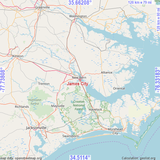
James City GPS coordinates[2]
35° 5' 19.572" North, 77° 2' 5.82" West
| Map corner | latitude | longitude |
|---|---|---|
| Upper-left | 35.66208°, | -77.73808° |
| Center: | 35.08877°, | -77.03495° |
| Lower-right: | 34.5114°, | -76.33183° |
| Map W x H: | 127.9×127.9 km | = 79.5×79.5mi |
| max Lat: | 71.29058° ⇑74.9% North |
| James City: | 35.08877° |
| min Lat: | ⇓25.1% South 19.06759° |
| min Long | James City | max Long |
| -171.73463° | -77.03495° | -66.98998° |
| W 80.5%⇐ | ⇒19.5% E |
Elevation
Elevation of James City is 3 m = 10 ft, and this is 291.8 m = 957 ft below average elevation for this country.
| Max E: |
3189 m = 10463 ft | 99.1% |
| Avg. | 294.8 m = 967 ft | |
| James City | 3 m = 10 ft | |
Min E: |
-60 m = -197 ft | 0.9% |
See also: United States elevation on elevation.city.
Geographical zone
James City is located in North temperate zone (between Tropic of Cancer and the Arctic Circle). Distance of this Northern Tropic circle is 1295.6 km =805 mi to South.| Distance of | km | miles | from James City |
|---|---|---|---|
| North Pole | 6105.6 | 3793.8 | to North |
| Arctic Circle | 3499.7 | 2174.6 | to North |
| Tropic Cancer | 1295.6 | 805 | to South |
| Equator | 3901.5 | 2424.3 | to South |


Nearby cities:
15 places around James City: (largest is in red/bold)
• Alliance
22.1 km =13.7 mi,  73°
73°
• Arapahoe
20.3 km =12.6 mi,  110°
110°
• Bayboro
24.8 km =15.4 mi,  75°
75°
• Brices Creek
6 km =3.7 mi,  232°
232°
• Fairfield Harbour
6.6 km =4.1 mi,  101°
101°
• Grantsboro
18.4 km =11.4 mi, 71°
• Havelock
26.3 km =16.3 mi,  152°
152°
• Maysville
27.2 km =16.9 mi,  221°
221°
• Neuse Forest
16.1 km =10 mi, 149°
• New Bern
2.3 km =1.4 mi,  339°
339°
• Oriental
31.8 km =19.8 mi, 101°
• River Bend
10.4 km =6.5 mi,  257°
257°
• Trent Woods
4.7 km =2.9 mi, 260°
• Trenton
29 km =18 mi,  265°
265°
• Vanceboro
26.7 km =16.6 mi, 336°
Sources, notices
• [Note1] Compared only with cities in United States existing in our database
• [Src1] Map data: © OpenStreetMap contributors (CC-BY-SA)
• [Src2] Other city data from geonames.org with taken over terms of usage.
• [Src3] Geographical zone / Annual Mean Temperature by Robert A. Rohde @ Wikipedia
