Trenton geodata
Trenton (North Carolina) is a seat of a second-order administrative division; located in United States in America/New_York (GMT-4) time zone. With population of 287 people, there are 20978 cities with bigger population in this country. Compared to other cities in United States, 75% of cities are located further ↑North; 79.4% of cities are located further ←West and 99.6% of cities have higher elevation than Trenton. Note1


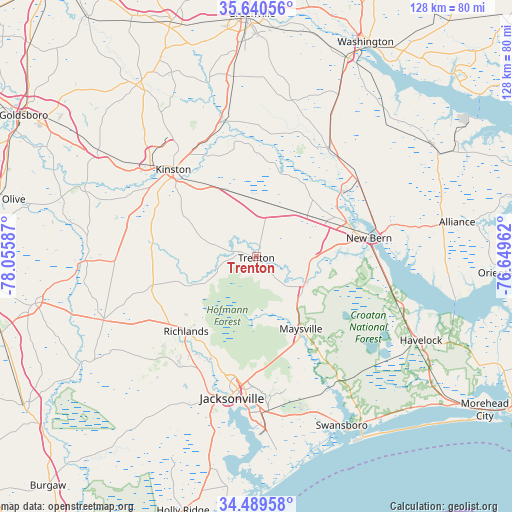
Trenton GPS coordinates[2]
35° 4' 1.56" North, 77° 21' 9.864" West
| Map corner | latitude | longitude |
|---|---|---|
| Upper-left | 35.64056°, | -78.05587° |
| Center: | 35.0671°, | -77.35274° |
| Lower-right: | 34.48958°, | -76.64962° |
| Map W x H: | 128×128 km | = 79.5×79.5mi |
| max Lat: | 71.29058° ⇑75% North |
| Trenton: | 35.0671° |
| min Lat: | ⇓25% South 19.06759° |
| min Long | Trenton | max Long |
| -171.73463° | -77.35274° | -66.98998° |
| W 79.4%⇐ | ⇒20.6% E |
Elevation
Elevation of Trenton is 1 m = 3 ft, and this is 293.8 m = 964 ft below average elevation for this country.
| Max E: |
3189 m = 10463 ft | 99.6% |
| Avg. | 294.8 m = 967 ft | |
| Trenton | 1 m = 3 ft | |
Min E: |
-60 m = -197 ft | 0.4% |
See also: United States elevation on elevation.city.
Geographical zone
Trenton is located in North temperate zone (between Tropic of Cancer and the Arctic Circle). Distance of this Northern Tropic circle is 1293.2 km =803.6 mi to South.| Distance of | km | miles | from Trenton |
|---|---|---|---|
| North Pole | 6108 | 3795.3 | to North |
| Arctic Circle | 3502.1 | 2176.1 | to North |
| Tropic Cancer | 1293.2 | 803.6 | to South |
| Equator | 3899.1 | 2422.8 | to South |


Nearby cities:
15 places around Trenton: (largest is in red/bold)
• Brices Creek
24.2 km =15 mi,  92°
92°
• Fairfield Harbour
35.4 km =22 mi, 88°
• Grifton
34.8 km =21.6 mi,  347°
347°
• Half Moon
28.5 km =17.7 mi,  199°
199°
• Jacksonville
35.5 km =22.1 mi,  191°
191°
• James City
29 km =18 mi, 85°
• Kinston
30.1 km =18.7 mi,  316°
316°
• Maysville
21.2 km =13.2 mi,  148°
148°
• New Bern
28.5 km =17.7 mi,  80°
80°
• Pink Hill
35.9 km =22.3 mi,  267°
267°
• Pumpkin Center
30.7 km =19.1 mi,  183°
183°
• Richlands
25.7 km =16 mi,  223°
223°
• River Bend
18.7 km =11.6 mi, 89°
• Trent Woods
24.3 km =15.1 mi, 86°
• Vanceboro
32.3 km =20.1 mi,  33°
33°
Sources, notices
• [Note1] Compared only with cities in United States existing in our database
• [Src1] Map data: © OpenStreetMap contributors (CC-BY-SA)
• [Src2] Other city data from geonames.org with taken over terms of usage.
• [Src3] Geographical zone / Annual Mean Temperature by Robert A. Rohde @ Wikipedia
