Millingport geodata
Millingport (North Carolina) is a populated place; located in United States in America/New_York (GMT-4) time zone. With population of 599 people, there are 19720 cities with bigger population in this country. Compared to other cities in United States, 73.3% of cities are located further ↑North; 71.7% of cities are located further ←West and 50.5% of cities have lower elevation than Millingport. Note1
Administrative division(s):
- Level 1: North Carolina
- Level 2: Stanly County
- Level 3: Township of Almond


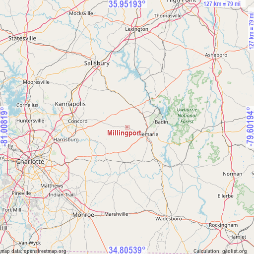
Millingport GPS coordinates[2]
35° 22' 50.52" North, 80° 18' 18.216" West
| Map corner | latitude | longitude |
|---|---|---|
| Upper-left | 35.95193°, | -81.00819° |
| Center: | 35.3807°, | -80.30506° |
| Lower-right: | 34.80539°, | -79.60194° |
| Map W x H: | 127.5×127.5 km | = 79.2×79.2mi |
| max Lat: | 71.29058° ⇑73.3% North |
| Millingport: | 35.3807° |
| min Lat: | ⇓26.7% South 19.06759° |
| min Long | Millingport | max Long |
| -171.73463° | -80.30506° | -66.98998° |
| W 71.7%⇐ | ⇒28.3% E |
Elevation
Elevation of Millingport is 200 m = 656 ft, and this is 94.8 m = 311 ft below average elevation for this country.
| Max E: |
3189 m = 10463 ft | 49.5% |
| Avg. | 294.8 m = 967 ft | |
| Millingport | 200 m = 656 ft | |
Min E: |
-60 m = -197 ft | 50.5% |
See also: United States elevation on elevation.city.
Geographical zone
Millingport is located in North temperate zone (between Tropic of Cancer and the Arctic Circle). Distance of this Northern Tropic circle is 1328 km =825.2 mi to South.| Distance of | km | miles | from Millingport |
|---|---|---|---|
| North Pole | 6073.1 | 3773.6 | to North |
| Arctic Circle | 3467.2 | 2154.4 | to North |
| Tropic Cancer | 1328 | 825.2 | to South |
| Equator | 3934 | 2444.5 | to South |


Nearby cities:
15 places around Millingport: (largest is in red/bold)
• Albemarle
10.1 km =6.3 mi,  109°
109°
• Badin
17.3 km =10.7 mi,  80°
80°
• Concord
25.3 km =15.7 mi,  277°
277°
• Faith
27 km =16.8 mi,  328°
328°
• Locust
17.3 km =10.7 mi,  219°
219°
• Midland
24.6 km =15.3 mi,  226°
226°
• Misenheimer
11.7 km =7.3 mi,  7°
7°
• Mount Pleasant
12 km =7.5 mi, 279°
• New London
10.4 km =6.5 mi,  48°
48°
• Norwood
24.6 km =15.3 mi,  136°
136°
• Oakboro
17.4 km =10.8 mi,  187°
187°
• Red Cross
13.4 km =8.3 mi,  200°
200°
• Richfield
10.8 km =6.7 mi,  23°
23°
• Rockwell
21.1 km =13.1 mi, 334°
• Stanfield
19.8 km =12.3 mi,  214°
214°
Sources, notices
• [Note1] Compared only with cities in United States existing in our database
• [Src1] Map data: © OpenStreetMap contributors (CC-BY-SA)
• [Src2] Other city data from geonames.org with taken over terms of usage.
• [Src3] Geographical zone / Annual Mean Temperature by Robert A. Rohde @ Wikipedia
