Albemarle geodata
Albemarle (North Carolina) is a seat of a second-order administrative division; located in United States in America/New_York (GMT-4) time zone. With population of 16,003 people, there are 3059 cities with bigger population in this country. Compared to other cities in United States, 73.4% of cities are located further ↑North; 72.2% of cities are located further ←West and 61.9% of cities have higher elevation than Albemarle. Note1
Administrative division(s):
- Level 1: North Carolina
- Level 2: Stanly County
- Level 3: Township of South Albemarle


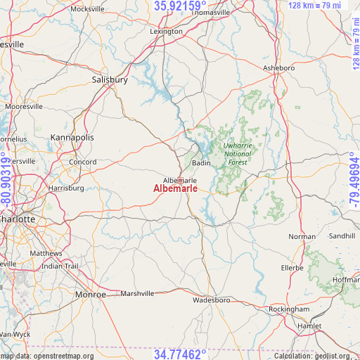
Albemarle GPS coordinates[2]
35° 21' 0.504" North, 80° 12' 0.216" West
| Map corner | latitude | longitude |
|---|---|---|
| Upper-left | 35.92159°, | -80.90319° |
| Center: | 35.35014°, | -80.20006° |
| Lower-right: | 34.77462°, | -79.49694° |
| Map W x H: | 127.5×127.5 km | = 79.2×79.2mi |
| max Lat: | 71.29058° ⇑73.4% North |
| Albemarle: | 35.35014° |
| min Lat: | ⇓26.6% South 19.06759° |
| min Long | Albemarle | max Long |
| -171.73463° | -80.20006° | -66.98998° |
| W 72.2%⇐ | ⇒27.8% E |
Elevation
Elevation of Albemarle is 145 m = 476 ft, and this is 149.8 m = 491 ft below average elevation for this country.
| Max E: |
3189 m = 10463 ft | 61.9% |
| Avg. | 294.8 m = 967 ft | |
| Albemarle | 145 m = 476 ft | |
Min E: |
-60 m = -197 ft | 38.1% |
See also: United States elevation on elevation.city.
Geographical zone
Albemarle is located in North temperate zone (between Tropic of Cancer and the Arctic Circle). Distance of this Northern Tropic circle is 1324.6 km =823.1 mi to South.| Distance of | km | miles | from Albemarle |
|---|---|---|---|
| North Pole | 6076.5 | 3775.8 | to North |
| Arctic Circle | 3470.6 | 2156.5 | to North |
| Tropic Cancer | 1324.6 | 823.1 | to South |
| Equator | 3930.6 | 2442.4 | to South |


Nearby cities:
15 places around Albemarle: (largest is in red/bold)
• Ansonville
28.5 km =17.7 mi,  163°
163°
• Badin
9.8 km =6.1 mi,  50°
50°
• Burnsville
26.7 km =16.6 mi,  188°
188°
• Locust
22.8 km =14.2 mi,  243°
243°
• Millingport
10.1 km =6.3 mi,  289°
289°
• Misenheimer
17 km =10.6 mi,  331°
331°
• Mount Gilead
23.4 km =14.5 mi,  129°
129°
• Mount Pleasant
22.1 km =13.7 mi,  284°
284°
• New London
10.5 km =6.5 mi,  350°
350°
• Norwood
16.3 km =10.1 mi,  153°
153°
• Oakboro
18.1 km =11.2 mi,  220°
220°
• Red Cross
16.9 km =10.5 mi, 236°
• Richfield
14.3 km =8.9 mi,  338°
338°
• Stanfield
24.3 km =15.1 mi, 237°
• Troy
27.7 km =17.2 mi,  88°
88°
Sources, notices
• [Note1] Compared only with cities in United States existing in our database
• [Src1] Map data: © OpenStreetMap contributors (CC-BY-SA)
• [Src2] Other city data from geonames.org with taken over terms of usage.
• [Src3] Geographical zone / Annual Mean Temperature by Robert A. Rohde @ Wikipedia
