Newton geodata
Newton (North Carolina) is a seat of a second-order administrative division; located in United States in America/New_York (GMT-4) time zone. With population of 13,035 people, there are 3662 cities with bigger population in this country. Compared to other cities in United States, 71.9% of cities are located further ↑North; 68.8% of cities are located further ←West and 74.5% of cities have lower elevation than Newton. Note1
Administrative division(s):
- Level 1: North Carolina
- Level 2: Catawba County
- Level 3: Township of Newton


Newton GPS coordinates[2]
35° 40' 11.496" North, 81° 13' 17.292" West
| Map corner | latitude | longitude |
|---|---|---|
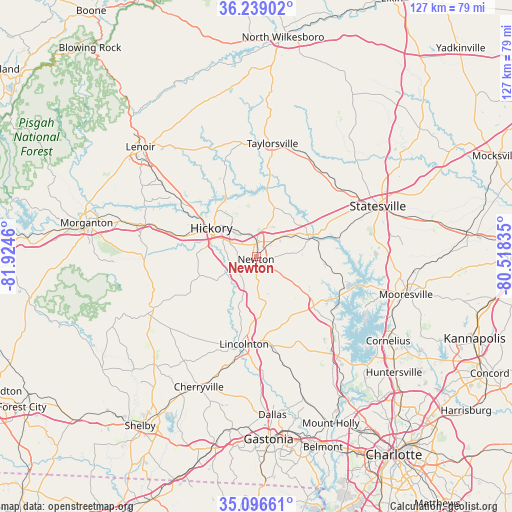
| Upper-left | 36.23902°, | -81.9246° |
| Center: | 35.66986°, | -81.22147° |
| Lower-right: | 35.09661°, | -80.51835° |
| Map W x H: | 127×127 km | = 78.9×78.9mi |
| max Lat: | 71.29058° ⇑71.9% North |
| Newton: | 35.66986° |
| min Lat: | ⇓28.1% South 19.06759° |
| min Long | Newton | max Long |
| -171.73463° | -81.22147° | -66.98998° |
| W 68.8%⇐ | ⇒31.2% E |
Elevation
Elevation of Newton is 310 m = 1017 ft, and this is 15.2 m = 50 ft above average elevation for this country.
| Max E: |
3189 m = 10463 ft | 25.5% |
| Newton | 310 m 1017 ft | |
| Avg. | 294.8 m = 967 ft | |
Min E: |
-60 m = -197 ft | 74.5% |
See also: United States elevation on elevation.city.
Geographical zone
Newton is located in North temperate zone (between Tropic of Cancer and the Arctic Circle). Distance of this Northern Tropic circle is 1360.2 km =845.2 mi to South.| Distance of | km | miles | from Newton |
|---|---|---|---|
| North Pole | 6040.9 | 3753.6 | to North |
| Arctic Circle | 3435.1 | 2134.5 | to North |
| Tropic Cancer | 1360.2 | 845.2 | to South |
| Equator | 3966.1 | 2464.4 | to South |


Nearby cities:
15 places around Newton: (largest is in red/bold)
• Bethlehem
19 km =11.8 mi,  335°
335°
• Boger City
21 km =13 mi,  178°
178°
• Catawba
13.8 km =8.6 mi,  72°
72°
• Claremont
8.4 km =5.2 mi,  53°
53°
• Conover
4.1 km =2.5 mi,  3°
3°
• Hickory
12.9 km =8 mi,  303°
303°
• Hildebran
18.8 km =11.7 mi,  285°
285°
• Lincolnton
22 km =13.7 mi,  187°
187°
• Longview
16 km =9.9 mi, 294°
• Maiden
10.5 km =6.5 mi, 175°
• Mountain View
13.4 km =8.3 mi,  276°
276°
• Northlakes
18.6 km =11.6 mi,  311°
311°
• Pumpkin Center
18.2 km =11.3 mi,  156°
156°
• Saint Stephens
11.5 km =7.1 mi, 336°
• Sherrills Ford
21.9 km =13.6 mi,  104°
104°
Sources, notices
• [Note1] Compared only with cities in United States existing in our database
• [Src1] Map data: © OpenStreetMap contributors (CC-BY-SA)
• [Src2] Other city data from geonames.org with taken over terms of usage.
• [Src3] Geographical zone / Annual Mean Temperature by Robert A. Rohde @ Wikipedia
