Hickory geodata
Hickory (North Carolina) is a populated place; located in United States in America/New_York (GMT-4) time zone. With population of 40,374 people, there are 1200 cities with bigger population in this country. Compared to other cities in United States, 71.6% of cities are located further ↑North; 68.4% of cities are located further ←West and 80% of cities have lower elevation than Hickory. Note1
Administrative division(s):
- Level 1: North Carolina
- Level 2: Catawba County
- Level 3: Township of Hickory


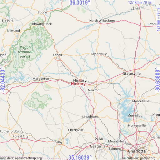
Hickory GPS coordinates[2]
35° 43' 59.484" North, 81° 20' 28.32" West
| Map corner | latitude | longitude |
|---|---|---|
| Upper-left | 36.3019°, | -82.04433° |
| Center: | 35.73319°, | -81.3412° |
| Lower-right: | 35.16039°, | -80.63808° |
| Map W x H: | 126.9×126.9 km | = 78.9×78.9mi |
| max Lat: | 71.29058° ⇑71.6% North |
| Hickory: | 35.73319° |
| min Lat: | ⇓28.4% South 19.06759° |
| min Long | Hickory | max Long |
| -171.73463° | -81.3412° | -66.98998° |
| W 68.4%⇐ | ⇒31.6% E |
Elevation
Elevation of Hickory is 354 m = 1161 ft, and this is 59.2 m = 194 ft above average elevation for this country.
| Max E: |
3189 m = 10463 ft | 20% |
| Hickory | 354 m 1161 ft | |
| Avg. | 294.8 m = 967 ft | |
Min E: |
-60 m = -197 ft | 80% |
See also: Hickory elevation on elevation.city.
Geographical zone
Hickory is located in North temperate zone (between Tropic of Cancer and the Arctic Circle). Distance of this Northern Tropic circle is 1367.2 km =849.5 mi to South.| Distance of | km | miles | from Hickory |
|---|---|---|---|
| North Pole | 6033.9 | 3749.3 | to North |
| Arctic Circle | 3428 | 2130.1 | to North |
| Tropic Cancer | 1367.2 | 849.5 | to South |
| Equator | 3973.2 | 2468.8 | to South |


Nearby cities:
15 places around Hickory: (largest is in red/bold)
• Bethlehem
10.7 km =6.6 mi,  16°
16°
• Claremont
17.7 km =11 mi,  96°
96°
• Connelly Springs
15.6 km =9.7 mi,  273°
273°
• Conover
11.4 km =7.1 mi,  105°
105°
• Granite Falls
10.7 km =6.6 mi,  311°
311°
• Hildebran
7.6 km =4.7 mi,  253°
253°
• Icard
11.7 km =7.3 mi, 266°
• Longview
3.8 km =2.4 mi,  263°
263°
• Mountain View
6.1 km =3.8 mi,  204°
204°
• Newton
12.9 km =8 mi,  123°
123°
• Northlakes
6.2 km =3.9 mi,  330°
330°
• Rhodhiss
9.3 km =5.8 mi,  299°
299°
• Rutherford College
16.5 km =10.3 mi,  275°
275°
• Saint Stephens
7.1 km =4.4 mi,  60°
60°
• Sawmills
15.8 km =9.8 mi, 310°
Sources, notices
• [Note1] Compared only with cities in United States existing in our database
• [Src1] Map data: © OpenStreetMap contributors (CC-BY-SA)
• [Src2] Other city data from geonames.org with taken over terms of usage.
• [Src3] Geographical zone / Annual Mean Temperature by Robert A. Rohde @ Wikipedia
