Rowland geodata
Rowland (North Carolina) is a populated place; located in United States in America/New_York (GMT-4) time zone. With population of 1,050 people, there are 15959 cities with bigger population in this country. Compared to other cities in United States, 77.5% of cities are located further ↑North; 75.2% of cities are located further ←West and 81.6% of cities have higher elevation than Rowland. Note1
Administrative division(s):
- Level 1: North Carolina
- Level 2: Robeson County
- Level 3: Township of Rowland


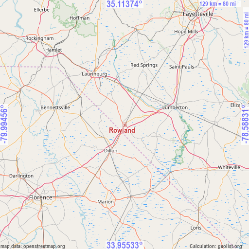
Rowland GPS coordinates[2]
34° 32' 11.58" North, 79° 17' 29.148" West
| Map corner | latitude | longitude |
|---|---|---|
| Upper-left | 35.11374°, | -79.99456° |
| Center: | 34.53655°, | -79.29143° |
| Lower-right: | 33.95533°, | -78.58831° |
| Map W x H: | 128.8×128.8 km | = 80×80mi |
| max Lat: | 71.29058° ⇑77.5% North |
| Rowland: | 34.53655° |
| min Lat: | ⇓22.5% South 19.06759° |
| min Long | Rowland | max Long |
| -171.73463° | -79.29143° | -66.98998° |
| W 75.2%⇐ | ⇒24.8% E |
Elevation
Elevation of Rowland is 40 m = 131 ft, and this is 254.8 m = 836 ft below average elevation for this country.
| Max E: |
3189 m = 10463 ft | 81.6% |
| Avg. | 294.8 m = 967 ft | |
| Rowland | 40 m = 131 ft | |
Min E: |
-60 m = -197 ft | 18.4% |
See also: United States elevation on elevation.city.
Geographical zone
Rowland is located in North temperate zone (between Tropic of Cancer and the Arctic Circle). Distance of this Northern Tropic circle is 1234.2 km =766.9 mi to South.| Distance of | km | miles | from Rowland |
|---|---|---|---|
| North Pole | 6167 | 3832 | to North |
| Arctic Circle | 3561.1 | 2212.8 | to North |
| Tropic Cancer | 1234.2 | 766.9 | to South |
| Equator | 3840.1 | 2386.1 | to South |


Nearby cities:
15 places around Rowland: (largest is in red/bold)
• Barker Ten Mile
32 km =19.9 mi,  60°
60°
• Clio
23.8 km =14.8 mi,  281°
281°
• Dillon
15.2 km =9.4 mi,  208°
208°
• Fair Bluff
34 km =21.1 mi,  136°
136°
• Fairmont
16.8 km =10.4 mi,  105°
105°
• Lake View
24.2 km =15 mi,  151°
151°
• Latta
25.6 km =15.9 mi, 210°
• Laurinburg
30.7 km =19.1 mi,  329°
329°
• Lumberton
27.3 km =17 mi,  70°
70°
• Maxton
22.7 km =14.1 mi,  346°
346°
• McColl
27.5 km =17.1 mi,  302°
302°
• Mullins
36.9 km =22.9 mi,  174°
174°
• Pembroke
18.2 km =11.3 mi,  28°
28°
• Prospect
22.6 km =14 mi,  14°
14°
• Red Springs
32.5 km =20.2 mi,  17°
17°
Sources, notices
• [Note1] Compared only with cities in United States existing in our database
• [Src1] Map data: © OpenStreetMap contributors (CC-BY-SA)
• [Src2] Other city data from geonames.org with taken over terms of usage.
• [Src3] Geographical zone / Annual Mean Temperature by Robert A. Rohde @ Wikipedia
