Dillon geodata
Dillon (South Carolina) is a seat of a second-order administrative division; located in United States in America/New_York (GMT-4) time zone. With population of 6,677 people, there are 5997 cities with bigger population in this country. Compared to other cities in United States, 78% of cities are located further ↑North; 75.1% of cities are located further ←West and 84.8% of cities have higher elevation than Dillon. Note1


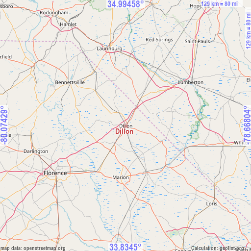
Dillon GPS coordinates[2]
34° 24' 59.58" North, 79° 22' 16.176" West
| Map corner | latitude | longitude |
|---|---|---|
| Upper-left | 34.99458°, | -80.07429° |
| Center: | 34.41655°, | -79.37116° |
| Lower-right: | 33.8345°, | -78.66804° |
| Map W x H: | 129×129 km | = 80.2×80.2mi |
| max Lat: | 71.29058° ⇑78% North |
| Dillon: | 34.41655° |
| min Lat: | ⇓22% South 19.06759° |
| min Long | Dillon | max Long |
| -171.73463° | -79.37116° | -66.98998° |
| W 75.1%⇐ | ⇒24.9% E |
Elevation
Elevation of Dillon is 29 m = 95 ft, and this is 265.8 m = 872 ft below average elevation for this country.
| Max E: |
3189 m = 10463 ft | 84.8% |
| Avg. | 294.8 m = 967 ft | |
| Dillon | 29 m = 95 ft | |
Min E: |
-60 m = -197 ft | 15.2% |
See also: United States elevation on elevation.city.
Geographical zone
Dillon is located in North temperate zone (between Tropic of Cancer and the Arctic Circle). Distance of this Northern Tropic circle is 1220.8 km =758.6 mi to South.| Distance of | km | miles | from Dillon |
|---|---|---|---|
| North Pole | 6180.3 | 3840.3 | to North |
| Arctic Circle | 3574.4 | 2221 | to North |
| Tropic Cancer | 1220.8 | 758.6 | to South |
| Equator | 3826.8 | 2377.9 | to South |


Nearby cities:
15 places around Dillon: (largest is in red/bold)
• Bennettsville
36.4 km =22.6 mi,  307°
307°
• Clio
24.2 km =15 mi,  318°
318°
• Fair Bluff
32.7 km =20.3 mi,  110°
110°
• Fairmont
25.2 km =15.7 mi,  69°
69°
• Lake View
20.4 km =12.7 mi, 112°
• Latta
10.4 km =6.5 mi,  211°
211°
• Lumberton
39.9 km =24.8 mi,  55°
55°
• Marion
26.6 km =16.5 mi,  185°
185°
• Maxton
35.5 km =22.1 mi,  3°
3°
• McColl
32.3 km =20.1 mi,  330°
330°
• Mullins
25.8 km =16 mi,  155°
155°
• Pembroke
33.5 km =20.8 mi,  28°
28°
• Prospect
37.5 km =23.3 mi,  20°
20°
• Quinby
38.9 km =24.2 mi,  239°
239°
• Rowland
15.2 km =9.4 mi, 28°
Sources, notices
• [Note1] Compared only with cities in United States existing in our database
• [Src1] Map data: © OpenStreetMap contributors (CC-BY-SA)
• [Src2] Other city data from geonames.org with taken over terms of usage.
• [Src3] Geographical zone / Annual Mean Temperature by Robert A. Rohde @ Wikipedia
