Rutherfordton geodata
Rutherfordton (North Carolina) is a seat of a second-order administrative division; located in United States in America/New_York (GMT-4) time zone. With population of 4,182 people, there are 8014 cities with bigger population in this country. Compared to other cities in United States, 73.3% of cities are located further ↑North; 65.7% of cities are located further ←West and 71.3% of cities have lower elevation than Rutherfordton. Note1
Administrative division(s):
- Level 1: North Carolina
- Level 2: Rutherford County
- Level 3: Township of Rutherfordton


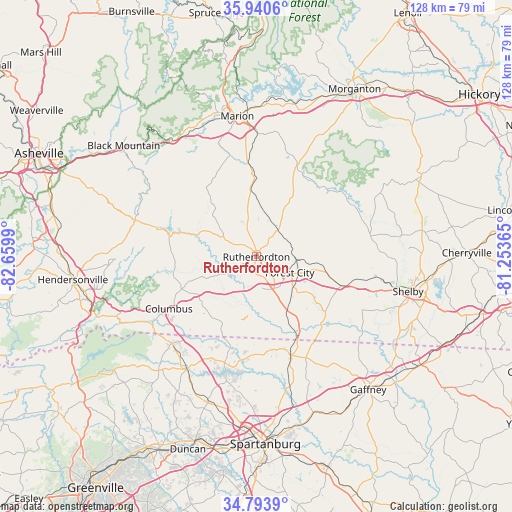
Rutherfordton GPS coordinates[2]
35° 22' 9.444" North, 81° 57' 24.372" West
| Map corner | latitude | longitude |
|---|---|---|
| Upper-left | 35.9406°, | -82.6599° |
| Center: | 35.36929°, | -81.95677° |
| Lower-right: | 34.7939°, | -81.25365° |
| Map W x H: | 127.5×127.5 km | = 79.2×79.2mi |
| max Lat: | 71.29058° ⇑73.3% North |
| Rutherfordton: | 35.36929° |
| min Lat: | ⇓26.7% South 19.06759° |
| min Long | Rutherfordton | max Long |
| -171.73463° | -81.95677° | -66.98998° |
| W 65.7%⇐ | ⇒34.3% E |
Elevation
Elevation of Rutherfordton is 292 m = 958 ft, and this is 2.8 m = 9 ft below average elevation for this country.
| Max E: |
3189 m = 10463 ft | 28.7% |
| Avg. | 294.8 m = 967 ft | |
| Rutherfordton | 292 m = 958 ft | |
Min E: |
-60 m = -197 ft | 71.3% |
See also: United States elevation on elevation.city.
Geographical zone
Rutherfordton is located in North temperate zone (between Tropic of Cancer and the Arctic Circle). Distance of this Northern Tropic circle is 1326.8 km =824.4 mi to South.| Distance of | km | miles | from Rutherfordton |
|---|---|---|---|
| North Pole | 6074.4 | 3774.5 | to North |
| Arctic Circle | 3468.5 | 2155.2 | to North |
| Tropic Cancer | 1326.8 | 824.4 | to South |
| Equator | 3932.7 | 2443.7 | to South |


Nearby cities:
15 places around Rutherfordton: (largest is in red/bold)
• Alexander Mills
11 km =6.8 mi,  126°
126°
• Boiling Springs
29.2 km =18.1 mi,  115°
115°
• Caroleen
17.6 km =10.9 mi, 123°
• Chesnee
26.1 km =16.2 mi,  160°
160°
• Cliffside
22.4 km =13.9 mi, 130°
• Columbus
25.3 km =15.7 mi,  239°
239°
• Ellenboro
18.5 km =11.5 mi,  104°
104°
• Forest City
9.2 km =5.7 mi, 115°
• Kingstown
31.3 km =19.4 mi,  93°
93°
• Lake Lure
23.4 km =14.5 mi,  286°
286°
• Landrum
30.2 km =18.8 mi,  224°
224°
• Polkville
29 km =18 mi,  79°
79°
• Spindale
2.7 km =1.7 mi,  112°
112°
• Tryon
31.2 km =19.4 mi,  234°
234°
• West Marion
32.7 km =20.3 mi,  349°
349°
Sources, notices
• [Note1] Compared only with cities in United States existing in our database
• [Src1] Map data: © OpenStreetMap contributors (CC-BY-SA)
• [Src2] Other city data from geonames.org with taken over terms of usage.
• [Src3] Geographical zone / Annual Mean Temperature by Robert A. Rohde @ Wikipedia
