Silver Lake geodata
Silver Lake (North Carolina) is a populated place; located in United States in America/New_York (GMT-4) time zone. With population of 5,598 people, there are 6680 cities with bigger population in this country. Compared to other cities in United States, 79.3% of cities are located further ↑North; 78% of cities are located further ←West and 93.9% of cities have higher elevation than Silver Lake. Note1
Administrative division(s):
- Level 1: North Carolina
- Level 2: New Hanover County
- Level 3: Township of Masonboro


Silver Lake GPS coordinates[2]
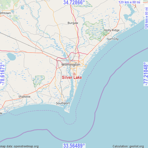
34° 8' 55.608" North, 77° 54' 48.96" West
| Map corner | latitude | longitude |
|---|---|---|
| Upper-left | 34.72866°, | -78.61673° |
| Center: | 34.14878°, | -77.9136° |
| Lower-right: | 33.56489°, | -77.21048° |
| Map W x H: | 129.4×129.4 km | = 80.4×80.4mi |
| max Lat: | 71.29058° ⇑79.3% North |
| Silver Lake: | 34.14878° |
| min Lat: | ⇓20.7% South 19.06759° |
| min Long | Silver Lake | max Long |
| -171.73463° | -77.9136° | -66.98998° |
| W 78%⇐ | ⇒22% E |
Elevation
Elevation of Silver Lake is 10 m = 33 ft, and this is 284.8 m = 934 ft below average elevation for this country.
| Max E: |
3189 m = 10463 ft | 93.9% |
| Avg. | 294.8 m = 967 ft | |
| Silver Lake | 10 m = 33 ft | |
Min E: |
-60 m = -197 ft | 6.1% |
See also: United States elevation on elevation.city.
Geographical zone
Silver Lake is located in North temperate zone (between Tropic of Cancer and the Arctic Circle). Distance of this Northern Tropic circle is 1191.1 km =740.1 mi to South.| Distance of | km | miles | from Silver Lake |
|---|---|---|---|
| North Pole | 6210.1 | 3858.8 | to North |
| Arctic Circle | 3604.2 | 2239.5 | to North |
| Tropic Cancer | 1191.1 | 740.1 | to South |
| Equator | 3797 | 2359.3 | to South |


Nearby cities:
15 places around Silver Lake: (largest is in red/bold)
• Belville
10.3 km =6.4 mi,  332°
332°
• Carolina Beach
12.8 km =8 mi,  171°
171°
• Hightsville
13.5 km =8.4 mi,  352°
352°
• Kings Grant
13.5 km =8.4 mi,  19°
19°
• Kure Beach
16.9 km =10.5 mi,  178°
178°
• Leland
17 km =10.6 mi,  314°
314°
• Masonboro
7 km =4.3 mi,  60°
60°
• Myrtle Grove
3.3 km =2.1 mi,  118°
118°
• Navassa
14.7 km =9.1 mi,  323°
323°
• Ogden
16.3 km =10.1 mi,  32°
32°
• Sea Breeze
9.7 km =6 mi, 167°
• Seagate
9.3 km =5.8 mi,  43°
43°
• Wilmington
9 km =5.6 mi,  341°
341°
• Wrightsboro
15.6 km =9.7 mi,  357°
357°
• Wrightsville Beach
12.7 km =7.9 mi, 58°
Sources, notices
• [Note1] Compared only with cities in United States existing in our database
• [Src1] Map data: © OpenStreetMap contributors (CC-BY-SA)
• [Src2] Other city data from geonames.org with taken over terms of usage.
• [Src3] Geographical zone / Annual Mean Temperature by Robert A. Rohde @ Wikipedia
