Wilmington geodata
Wilmington (North Carolina) is a seat of a second-order administrative division; located in United States in America/New_York (GMT-4) time zone. With population of 115,933 people, there are 274 cities with bigger population in this country. Compared to other cities in United States, 78.9% of cities are located further ↑North; 77.9% of cities are located further ←West and 91% of cities have higher elevation than Wilmington. Note1
Administrative division(s):
- Level 1: North Carolina
- Level 2: New Hanover County
- Level 3: Township of Wilmington


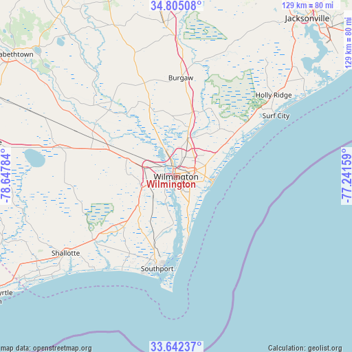
Wilmington GPS coordinates[2]
34° 13' 32.628" North, 77° 56' 40.956" West
| Map corner | latitude | longitude |
|---|---|---|
| Upper-left | 34.80508°, | -78.64784° |
| Center: | 34.22573°, | -77.94471° |
| Lower-right: | 33.64237°, | -77.24159° |
| Map W x H: | 129.3×129.3 km | = 80.3×80.3mi |
| max Lat: | 71.29058° ⇑78.9% North |
| Wilmington: | 34.22573° |
| min Lat: | ⇓21.1% South 19.06759° |
| min Long | Wilmington | max Long |
| -171.73463° | -77.94471° | -66.98998° |
| W 77.9%⇐ | ⇒22.1% E |
Elevation
Elevation of Wilmington is 14 m = 46 ft, and this is 280.8 m = 921 ft below average elevation for this country.
| Max E: |
3189 m = 10463 ft | 91% |
| Avg. | 294.8 m = 967 ft | |
| Wilmington | 14 m = 46 ft | |
Min E: |
-60 m = -197 ft | 9% |
See also: Wilmington elevation on elevation.city.
Geographical zone
Wilmington is located in North temperate zone (between Tropic of Cancer and the Arctic Circle). Distance of this Northern Tropic circle is 1199.6 km =745.4 mi to South.| Distance of | km | miles | from Wilmington |
|---|---|---|---|
| North Pole | 6201.5 | 3853.4 | to North |
| Arctic Circle | 3595.6 | 2234.2 | to North |
| Tropic Cancer | 1199.6 | 745.4 | to South |
| Equator | 3805.5 | 2364.6 | to South |


Nearby cities:
15 places around Wilmington: (largest is in red/bold)
• Belville
2 km =1.2 mi,  285°
285°
• Hightsville
5 km =3.1 mi,  13°
13°
• Kings Grant
8.5 km =5.3 mi,  60°
60°
• Leland
9.8 km =6.1 mi, 290°
• Masonboro
10.3 km =6.4 mi,  119°
119°
• Murraysville
11.8 km =7.3 mi,  48°
48°
• Myrtle Grove
11.7 km =7.3 mi,  150°
150°
• Navassa
6.6 km =4.1 mi,  299°
299°
• Northchase
11 km =6.8 mi,  34°
34°
• Ogden
12.7 km =7.9 mi,  65°
65°
• Seagate
9.5 km =5.9 mi,  101°
101°
• Silver Lake
9 km =5.6 mi,  161°
161°
• Skippers Corner
13.9 km =8.6 mi,  16°
16°
• Wrightsboro
7.3 km =4.5 mi, 17°
• Wrightsville Beach
13.8 km =8.6 mi, 97°
Sources, notices
• [Note1] Compared only with cities in United States existing in our database
• [Src1] Map data: © OpenStreetMap contributors (CC-BY-SA)
• [Src2] Other city data from geonames.org with taken over terms of usage.
• [Src3] Geographical zone / Annual Mean Temperature by Robert A. Rohde @ Wikipedia
