White Plains geodata
White Plains (North Carolina) is a populated place; located in United States in America/New_York (GMT-4) time zone. With population of 1,074 people, there are 15821 cities with bigger population in this country. Compared to other cities in United States, 68.2% of cities are located further ↑North; 70.5% of cities are located further ←West and 78.8% of cities have lower elevation than White Plains. Note1
Administrative division(s):
- Level 1: North Carolina
- Level 2: Surry County
- Level 3: Township of Mount Airy


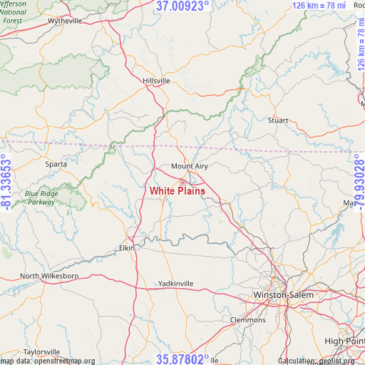
White Plains GPS coordinates[2]
36° 26' 44.484" North, 80° 38' 0.24" West
| Map corner | latitude | longitude |
|---|---|---|
| Upper-left | 37.00923°, | -81.33653° |
| Center: | 36.44569°, | -80.6334° |
| Lower-right: | 35.87802°, | -79.93028° |
| Map W x H: | 125.8×125.8 km | = 78.2×78.2mi |
| max Lat: | 71.29058° ⇑68.2% North |
| White Plains: | 36.44569° |
| min Lat: | ⇓31.8% South 19.06759° |
| min Long | White Plains | max Long |
| -171.73463° | -80.6334° | -66.98998° |
| W 70.5%⇐ | ⇒29.5% E |
Elevation
Elevation of White Plains is 343 m = 1125 ft, and this is 48.2 m = 158 ft above average elevation for this country.
| Max E: |
3189 m = 10463 ft | 21.2% |
| White Plains | 343 m 1125 ft | |
| Avg. | 294.8 m = 967 ft | |
Min E: |
-60 m = -197 ft | 78.8% |
See also: United States elevation on elevation.city.
Geographical zone
White Plains is located in North temperate zone (between Tropic of Cancer and the Arctic Circle). Distance of this Northern Tropic circle is 1446.5 km =898.8 mi to South.| Distance of | km | miles | from White Plains |
|---|---|---|---|
| North Pole | 5954.7 | 3700.1 | to North |
| Arctic Circle | 3348.8 | 2080.8 | to North |
| Tropic Cancer | 1446.5 | 898.8 | to South |
| Equator | 4052.4 | 2518 | to South |


Nearby cities:
15 places around White Plains: (largest is in red/bold)
• Arlington
30.2 km =18.8 mi,  216°
216°
• Boonville
24.6 km =15.3 mi,  195°
195°
• Cana
16.4 km =10.2 mi,  347°
347°
• Dobson
9.7 km =6 mi,  235°
235°
• East Bend
27.7 km =17.2 mi,  156°
156°
• Elkin
29.5 km =18.3 mi, 220°
• Flat Rock
9.3 km =5.8 mi,  37°
37°
• Jonesville
29.7 km =18.5 mi, 219°
• King
30.6 km =19 mi,  126°
126°
• Mount Airy
6.4 km =4 mi,  21°
21°
• Pilot Mountain
16.1 km =10 mi,  114°
114°
• Pinnacle
22.1 km =13.7 mi, 125°
• Pleasant Hill
30.7 km =19.1 mi,  226°
226°
• Thurmond
27.8 km =17.3 mi,  251°
251°
• Toast
6.1 km =3.8 mi,  5°
5°
Sources, notices
• [Note1] Compared only with cities in United States existing in our database
• [Src1] Map data: © OpenStreetMap contributors (CC-BY-SA)
• [Src2] Other city data from geonames.org with taken over terms of usage.
• [Src3] Geographical zone / Annual Mean Temperature by Robert A. Rohde @ Wikipedia
