Cape May Court House geodata
Cape May Court House (New Jersey) is a seat of a second-order administrative division; located in United States in America/New_York (GMT-4) time zone. With population of 5,338 people, there are 6886 cities with bigger population in this country. Compared to other cities in United States, 54.1% of cities are located further ↑North; 87.8% of cities are located further ←West and 93% of cities have higher elevation than Cape May Court House. Note1
Administrative division(s):
- Level 1: New Jersey
- Level 2: Cape May County
- Level 3: Township of Middle
Current local time in Cape May Court House:
07:12 PM, WednesdayDifference from your time zone: hours


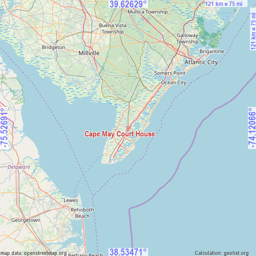
Cape May Court House GPS coordinates[2]
39° 4' 57.396" North, 74° 49' 25.608" West
| Map corner | latitude | longitude |
|---|---|---|
| Upper-left | 39.62629°, | -75.52691° |
| Center: | 39.08261°, | -74.82378° |
| Lower-right: | 38.53471°, | -74.12066° |
| Map W x H: | 121.4×121.4 km | = 75.4×75.4mi |
| max Lat: | 71.29058° ⇑54.1% North |
| Cape May Court House: | 39.08261° |
| min Lat: | ⇓45.9% South 19.06759° |
| min Long | Cape May Court | max Long |
| -171.73463° | -74.82378° | -66.98998° |
| W 87.8%⇐ | ⇒12.2% E |
Elevation
Elevation of Cape May Court House is 11 m = 36 ft, and this is 283.8 m = 931 ft below average elevation for this country.
| Max E: |
3189 m = 10463 ft | 93% |
| Avg. | 294.8 m = 967 ft | |
| Cape May Court House | 11 m = 36 ft | |
Min E: |
-60 m = -197 ft | 7% |
See also: United States elevation on elevation.city.
Geographical zone
Cape May Court House is located in North temperate zone (between Tropic of Cancer and the Arctic Circle). Distance of this Northern Tropic circle is 1739.7 km =1081 mi to South.| Distance of | km | miles | from Cape May Court House |
|---|---|---|---|
| North Pole | 5661.5 | 3517.9 | to North |
| Arctic Circle | 3055.6 | 1898.7 | to North |
| Tropic Cancer | 1739.7 | 1081 | to South |
| Equator | 4345.6 | 2700.2 | to South |


Nearby cities:
15 places around Cape May Court House: (largest is in red/bold)
• Avalon
9.4 km =5.8 mi,  77°
77°
• Burleigh
4.8 km =3 mi,  210°
210°
• Erma
12.5 km =7.8 mi, 212°
• North Cape May
16.1 km =10 mi,  226°
226°
• North Wildwood
9.4 km =5.8 mi,  166°
166°
• Rio Grande
9.1 km =5.7 mi, 213°
• Sea Isle City
13.8 km =8.6 mi,  55°
55°
• Stone Harbor
6.7 km =4.2 mi,  121°
121°
• Villas
11.6 km =7.2 mi,  238°
238°
• West Wildwood
8.9 km =5.5 mi,  180°
180°
• Whitesboro
5.6 km =3.5 mi, 210°
• Whitesboro-Burleigh
5.7 km =3.5 mi,  219°
219°
• Wildwood
10.1 km =6.3 mi, 175°
• Wildwood Crest
12 km =7.5 mi, 184°
• Woodbine
17.7 km =11 mi,  2°
2°
Sources, notices
• [Note1] Compared only with cities in United States existing in our database
• [Src1] Map data: © OpenStreetMap contributors (CC-BY-SA)
• [Src2] Other city data from geonames.org with taken over terms of usage.
• [Src3] Geographical zone / Annual Mean Temperature by Robert A. Rohde @ Wikipedia
