Whitesboro-Burleigh geodata
Whitesboro-Burleigh (New Jersey) is a populated place; located in United States in America/New_York (GMT-4) time zone. With population of 2,205 people, there are 11323 cities with bigger population in this country. Compared to other cities in United States, 54.4% of cities are located further ↑North; 87.7% of cities are located further ←West and 93% of cities have higher elevation than Whitesboro-Burleigh. Note1
Administrative division(s):
- Level 1: New Jersey
- Level 2: Cape May County
- Level 3: Township of Middle


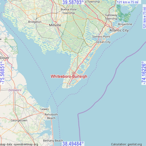
Whitesboro-Burleigh GPS coordinates[2]
39° 2' 34.98" North, 74° 51' 55.368" West
| Map corner | latitude | longitude |
|---|---|---|
| Upper-left | 39.58703°, | -75.56851° |
| Center: | 39.04305°, | -74.86538° |
| Lower-right: | 38.49484°, | -74.16226° |
| Map W x H: | 121.4×121.4 km | = 75.4×75.4mi |
| max Lat: | 71.29058° ⇑54.4% North |
| Whitesboro-Burleigh: | 39.04305° |
| min Lat: | ⇓45.6% South 19.06759° |
| min Long | Whitesboro-Burl | max Long |
| -171.73463° | -74.86538° | -66.98998° |
| W 87.7%⇐ | ⇒12.3% E |
Elevation
Elevation of Whitesboro-Burleigh is 11 m = 36 ft, and this is 283.8 m = 931 ft below average elevation for this country.
| Max E: |
3189 m = 10463 ft | 93% |
| Avg. | 294.8 m = 967 ft | |
| Whitesboro-Burleigh | 11 m = 36 ft | |
Min E: |
-60 m = -197 ft | 7% |
See also: United States elevation on elevation.city.
Geographical zone
Whitesboro-Burleigh is located in North temperate zone (between Tropic of Cancer and the Arctic Circle). Distance of this Northern Tropic circle is 1735.3 km =1078.3 mi to South.| Distance of | km | miles | from Whitesboro-Burleigh |
|---|---|---|---|
| North Pole | 5665.9 | 3520.6 | to North |
| Arctic Circle | 3060 | 1901.4 | to North |
| Tropic Cancer | 1735.3 | 1078.3 | to South |
| Equator | 4341.2 | 2697.5 | to South |


Nearby cities:
15 places around Whitesboro-Burleigh: (largest is in red/bold)
• Avalon
14.3 km =8.9 mi,  63°
63°
• Burleigh
1.2 km =0.7 mi,  76°
76°
• Cape May
12.5 km =7.8 mi,  196°
196°
• Cape May Court House
5.7 km =3.5 mi,  39°
39°
• Erma
6.9 km =4.3 mi,  207°
207°
• North Cape May
10.5 km =6.5 mi,  229°
229°
• North Wildwood
7.4 km =4.6 mi,  129°
129°
• Rio Grande
3.5 km =2.2 mi, 203°
• Stone Harbor
9.3 km =5.8 mi, 84°
• Villas
6.5 km =4 mi,  255°
255°
• West Cape May
13.4 km =8.3 mi, 209°
• West Wildwood
5.8 km =3.6 mi,  141°
141°
• Whitesboro
0.9 km =0.6 mi,  121°
121°
• Wildwood
7.2 km =4.5 mi, 142°
• Wildwood Crest
8.1 km =5 mi,  160°
160°
Sources, notices
• [Note1] Compared only with cities in United States existing in our database
• [Src1] Map data: © OpenStreetMap contributors (CC-BY-SA)
• [Src2] Other city data from geonames.org with taken over terms of usage.
• [Src3] Geographical zone / Annual Mean Temperature by Robert A. Rohde @ Wikipedia
