Longport geodata
Longport (New Jersey) is a populated place; located in United States in America/New_York (GMT-4) time zone. With population of 886 people, there are 17069 cities with bigger population in this country. Compared to other cities in United States, 52.1% of cities are located further ↑North; 88.5% of cities are located further ←West and 98.8% of cities have higher elevation than Longport. Note1
Administrative division(s):
- Level 1: New Jersey
- Level 2: Atlantic County
- Level 3: Borough of Longport


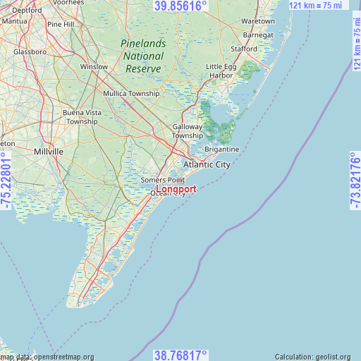
Longport GPS coordinates[2]
39° 18' 51.408" North, 74° 31' 29.568" West
| Map corner | latitude | longitude |
|---|---|---|
| Upper-left | 39.85616°, | -75.22801° |
| Center: | 39.31428°, | -74.52488° |
| Lower-right: | 38.76817°, | -73.82176° |
| Map W x H: | 121×121 km | = 75.2×75.2mi |
| max Lat: | 71.29058° ⇑52.1% North |
| Longport: | 39.31428° |
| min Lat: | ⇓47.9% South 19.06759° |
| min Long | Longport | max Long |
| -171.73463° | -74.52488° | -66.98998° |
| W 88.5%⇐ | ⇒11.5% E |
Elevation
Elevation of Longport is 4 m = 13 ft, and this is 290.8 m = 954 ft below average elevation for this country.
| Max E: |
3189 m = 10463 ft | 98.8% |
| Avg. | 294.8 m = 967 ft | |
| Longport | 4 m = 13 ft | |
Min E: |
-60 m = -197 ft | 1.2% |
See also: United States elevation on elevation.city.
Geographical zone
Longport is located in North temperate zone (between Tropic of Cancer and the Arctic Circle). Distance of this Northern Tropic circle is 1765.4 km =1097 mi to South.| Distance of | km | miles | from Longport |
|---|---|---|---|
| North Pole | 5635.7 | 3501.9 | to North |
| Arctic Circle | 3029.8 | 1882.6 | to North |
| Tropic Cancer | 1765.4 | 1097 | to South |
| Equator | 4371.3 | 2716.2 | to South |


Nearby cities:
15 places around Longport: (largest is in red/bold)
• Absecon
12.9 km =8 mi,  11°
11°
• Atlantic City
10.4 km =6.5 mi,  57°
57°
• Brigantine
17.4 km =10.8 mi,  52°
52°
• Estell Manor
21.6 km =13.4 mi,  300°
300°
• Linwood
5.2 km =3.2 mi, 303°
• Margate City
2.4 km =1.5 mi, 50°
• Northfield
6.6 km =4.1 mi,  340°
340°
• Ocean City
5.9 km =3.7 mi,  226°
226°
• Pleasantville
8.4 km =5.2 mi,  0°
0°
• Pomona
18.8 km =11.7 mi,  346°
346°
• Port Republic
23.2 km =14.4 mi, 8°
• Sea Isle City
23 km =14.3 mi,  218°
218°
• Smithville
20.8 km =12.9 mi,  16°
16°
• Somers Point
6 km =3.7 mi,  273°
273°
• Ventnor City
5 km =3.1 mi, 54°
Sources, notices
• [Note1] Compared only with cities in United States existing in our database
• [Src1] Map data: © OpenStreetMap contributors (CC-BY-SA)
• [Src2] Other city data from geonames.org with taken over terms of usage.
• [Src3] Geographical zone / Annual Mean Temperature by Robert A. Rohde @ Wikipedia
