Richwood geodata
Richwood (New Jersey) is a populated place; located in United States in America/New_York (GMT-4) time zone. With population of 3,459 people, there are 8899 cities with bigger population in this country. Compared to other cities in United States, 50.9% of cities are located further ↓South; 86.8% of cities are located further ←West and 79.7% of cities have higher elevation than Richwood. Note1
Administrative division(s):
- Level 1: New Jersey
- Level 2: Gloucester County
- Level 3: Township of Harrison


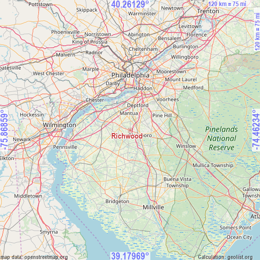
Richwood GPS coordinates[2]
39° 43' 21.396" North, 75° 9' 55.656" West
| Map corner | latitude | longitude |
|---|---|---|
| Upper-left | 40.26129°, | -75.86859° |
| Center: | 39.72261°, | -75.16546° |
| Lower-right: | 39.17969°, | -74.46234° |
| Map W x H: | 120.3×120.3 km | = 74.8×74.8mi |
| max Lat: | 71.29058° ⇑49.1% North |
| Richwood: | 39.72261° |
| min Lat: | ⇓50.9% South 19.06759° |
| min Long | Richwood | max Long |
| -171.73463° | -75.16546° | -66.98998° |
| W 86.8%⇐ | ⇒13.2% E |
Elevation
Elevation of Richwood is 48 m = 157 ft, and this is 246.8 m = 810 ft below average elevation for this country.
| Max E: |
3189 m = 10463 ft | 79.7% |
| Avg. | 294.8 m = 967 ft | |
| Richwood | 48 m = 157 ft | |
Min E: |
-60 m = -197 ft | 20.3% |
See also: United States elevation on elevation.city.
Geographical zone
Richwood is located in North temperate zone (between Tropic of Cancer and the Arctic Circle). Distance of this Northern Tropic circle is 1810.8 km =1125.2 mi to South.| Distance of | km | miles | from Richwood |
|---|---|---|---|
| North Pole | 5590.3 | 3473.7 | to North |
| Arctic Circle | 2984.4 | 1854.4 | to North |
| Tropic Cancer | 1810.8 | 1125.2 | to South |
| Equator | 4416.7 | 2744.4 | to South |


Nearby cities:
15 places around Richwood: (largest is in red/bold)
• Blackwood
12.4 km =7.7 mi,  44°
44°
• Clayton
9.4 km =5.8 mi,  137°
137°
• Elmer
14.2 km =8.8 mi,  181°
181°
• Glassboro
5.1 km =3.2 mi,  115°
115°
• Glendora
15.2 km =9.4 mi,  31°
31°
• Mullica Hill
5.3 km =3.3 mi,  290°
290°
• Oak Valley
8.7 km =5.4 mi,  1°
1°
• Paulsboro
13.6 km =8.5 mi,  331°
331°
• Pitman
3.1 km =1.9 mi,  68°
68°
• Swedesboro
12.7 km =7.9 mi,  282°
282°
• Turnersville
11.3 km =7 mi,  60°
60°
• Wenonah
8.1 km =5 mi,  10°
10°
• Williamstown
15.1 km =9.4 mi,  105°
105°
• Woodbury
12.9 km =8 mi, 4°
• Woodbury Heights
10.5 km =6.5 mi, 4°
Sources, notices
• [Note1] Compared only with cities in United States existing in our database
• [Src1] Map data: © OpenStreetMap contributors (CC-BY-SA)
• [Src2] Other city data from geonames.org with taken over terms of usage.
• [Src3] Geographical zone / Annual Mean Temperature by Robert A. Rohde @ Wikipedia
