South Toms River geodata
South Toms River (New Jersey) is a populated place; located in United States in America/New_York (GMT-4) time zone. With population of 3,736 people, there are 8540 cities with bigger population in this country. Compared to other cities in United States, 52.9% of cities are located further ↓South; 89.4% of cities are located further ←West and 95.7% of cities have higher elevation than South Toms River. Note1
Administrative division(s):
- Level 1: New Jersey
- Level 2: Ocean County
- Level 3: Borough of South Toms River


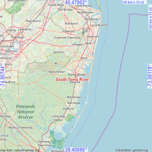
South Toms River GPS coordinates[2]
39° 56' 31.416" North, 74° 12' 15.516" West
| Map corner | latitude | longitude |
|---|---|---|
| Upper-left | 40.47902°, | -74.90744° |
| Center: | 39.94206°, | -74.20431° |
| Lower-right: | 39.40086°, | -73.50119° |
| Map W x H: | 119.9×119.9 km | = 74.5×74.5mi |
| max Lat: | 71.29058° ⇑47.1% North |
| South Toms River: | 39.94206° |
| min Lat: | ⇓52.9% South 19.06759° |
| min Long | South Toms Rive | max Long |
| -171.73463° | -74.20431° | -66.98998° |
| W 89.4%⇐ | ⇒10.6% E |
Elevation
Elevation of South Toms River is 8 m = 26 ft, and this is 286.8 m = 941 ft below average elevation for this country.
| Max E: |
3189 m = 10463 ft | 95.7% |
| Avg. | 294.8 m = 967 ft | |
| South Toms River | 8 m = 26 ft | |
Min E: |
-60 m = -197 ft | 4.3% |
See also: United States elevation on elevation.city.
Geographical zone
South Toms River is located in North temperate zone (between Tropic of Cancer and the Arctic Circle). Distance of this Northern Tropic circle is 1835.2 km =1140.3 mi to South.| Distance of | km | miles | from South Toms River |
|---|---|---|---|
| North Pole | 5565.9 | 3458.5 | to North |
| Arctic Circle | 2960 | 1839.3 | to North |
| Tropic Cancer | 1835.2 | 1140.3 | to South |
| Equator | 4441.1 | 2759.6 | to South |


Nearby cities:
15 places around South Toms River: (largest is in red/bold)
• Bayville
5.6 km =3.5 mi,  130°
130°
• Beachwood
1 km =0.6 mi,  109°
109°
• Holiday City South
3.1 km =1.9 mi,  293°
293°
• Holiday City-Berkeley
6.7 km =4.2 mi, 291°
• Holiday Heights
4.3 km =2.7 mi,  275°
275°
• Island Heights
4.6 km =2.9 mi,  90°
90°
• Leisure Village East
10.4 km =6.5 mi,  19°
19°
• Leisure Village West-Pine Lake Park
8.7 km =5.4 mi,  322°
322°
• Ocean Gate
6.3 km =3.9 mi, 105°
• Pine Beach
2.9 km =1.8 mi,  103°
103°
• Pine Lake Park
8.1 km =5 mi,  326°
326°
• Pine Ridge at Crestwood
9.5 km =5.9 mi, 278°
• Seaside Park
11 km =6.8 mi, 98°
• Silver Ridge
2.3 km =1.4 mi, 327°
• Toms River
1.4 km =0.9 mi, 22°
Sources, notices
• [Note1] Compared only with cities in United States existing in our database
• [Src1] Map data: © OpenStreetMap contributors (CC-BY-SA)
• [Src2] Other city data from geonames.org with taken over terms of usage.
• [Src3] Geographical zone / Annual Mean Temperature by Robert A. Rohde @ Wikipedia
