Holiday City-Berkeley geodata
Holiday City-Berkeley (New Jersey) is a populated place; located in United States in America/New_York (GMT-4) time zone. With population of 12,831 people, there are 3712 cities with bigger population in this country. Compared to other cities in United States, 53.2% of cities are located further ↓South; 89.2% of cities are located further ←West and 90.5% of cities have higher elevation than Holiday City-Berkeley. Note1
Current local time in Holiday City-Berkeley:
05:16 PM, WednesdayDifference from your time zone: hours


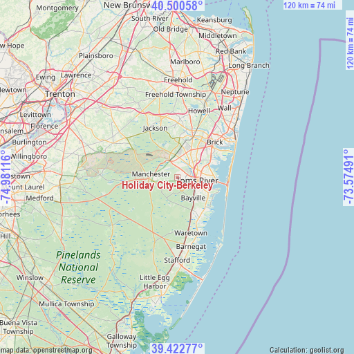
Holiday City-Berkeley GPS coordinates[2]
39° 57' 49.68" North, 74° 16' 40.908" West
| Map corner | latitude | longitude |
|---|---|---|
| Upper-left | 40.50058°, | -74.98116° |
| Center: | 39.9638°, | -74.27803° |
| Lower-right: | 39.42277°, | -73.57491° |
| Map W x H: | 119.8×119.8 km | = 74.4×74.4mi |
| max Lat: | 71.29058° ⇑46.8% North |
| Holiday City-Berkeley: | 39.9638° |
| min Lat: | ⇓53.2% South 19.06759° |
| min Long | Holiday City-Be | max Long |
| -171.73463° | -74.27803° | -66.98998° |
| W 89.2%⇐ | ⇒10.8% E |
Elevation
Elevation of Holiday City-Berkeley is 15 m = 49 ft, and this is 279.8 m = 918 ft below average elevation for this country.
| Max E: |
3189 m = 10463 ft | 90.5% |
| Avg. | 294.8 m = 967 ft | |
| Holiday City-Berkeley | 15 m = 49 ft | |
Min E: |
-60 m = -197 ft | 9.5% |
See also: United States elevation on elevation.city.
Geographical zone
Holiday City-Berkeley is located in North temperate zone (between Tropic of Cancer and the Arctic Circle). Distance of this Northern Tropic circle is 1837.6 km =1141.8 mi to South.| Distance of | km | miles | from Holiday City-Berkeley |
|---|---|---|---|
| North Pole | 5563.5 | 3457 | to North |
| Arctic Circle | 2957.6 | 1837.8 | to North |
| Tropic Cancer | 1837.6 | 1141.8 | to South |
| Equator | 4443.6 | 2761.1 | to South |


Nearby cities:
15 places around Holiday City-Berkeley: (largest is in red/bold)
• Beachwood
7.8 km =4.8 mi,  110°
110°
• Cedar Glen Lakes
10.5 km =6.5 mi,  263°
263°
• Cedar Glen West
8.8 km =5.5 mi,  351°
351°
• Crestwood Village
7.3 km =4.5 mi, 256°
• Holiday City South
3.6 km =2.2 mi, 108°
• Holiday Heights
2.9 km =1.8 mi,  134°
134°
• Lakehurst
6.3 km =3.9 mi,  333°
333°
• Leisure Knoll
6.3 km =3.9 mi, 348°
• Leisure Village West-Pine Lake Park
4.6 km =2.9 mi,  12°
12°
• Pine Beach
9.6 km =6 mi, 108°
• Pine Lake Park
4.7 km =2.9 mi,  22°
22°
• Pine Ridge at Crestwood
3.3 km =2.1 mi,  252°
252°
• Silver Ridge
5.1 km =3.2 mi,  95°
95°
• South Toms River
6.7 km =4.2 mi, 111°
• Toms River
6.9 km =4.3 mi, 99°
Sources, notices
• [Note1] Compared only with cities in United States existing in our database
• [Src1] Map data: © OpenStreetMap contributors (CC-BY-SA)
• [Src2] Other city data from geonames.org with taken over terms of usage.
• [Src3] Geographical zone / Annual Mean Temperature by Robert A. Rohde @ Wikipedia
