Geneva geodata
Geneva (Ohio) is a populated place; located in United States in America/New_York (GMT-4) time zone. With population of 6,447 people, there are 6144 cities with bigger population in this country. Compared to other cities in United States, 50.5% of cities are located further ↓South; 64.1% of cities are located further ←West and 73.3% of cities have lower elevation than Geneva. Note1


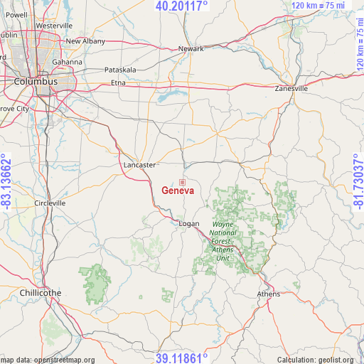
Geneva GPS coordinates[2]
39° 39' 43.236" North, 82° 26' 0.564" West
| Map corner | latitude | longitude |
|---|---|---|
| Upper-left | 40.20117°, | -83.13662° |
| Center: | 39.66201°, | -82.43349° |
| Lower-right: | 39.11861°, | -81.73037° |
| Map W x H: | 120.4×120.4 km | = 74.8×74.8mi |
| max Lat: | 71.29058° ⇑49.5% North |
| Geneva: | 39.66201° |
| min Lat: | ⇓50.5% South 19.06759° |
| min Long | Geneva | max Long |
| -171.73463° | -82.43349° | -66.98998° |
| W 64.1%⇐ | ⇒35.9% E |
Elevation
Elevation of Geneva is 303 m = 994 ft, and this is 8.2 m = 27 ft above average elevation for this country.
| Max E: |
3189 m = 10463 ft | 26.7% |
| Geneva | 303 m 994 ft | |
| Avg. | 294.8 m = 967 ft | |
Min E: |
-60 m = -197 ft | 73.3% |
See also: United States elevation on elevation.city.
Geographical zone
Geneva is located in North temperate zone (between Tropic of Cancer and the Arctic Circle). Distance of this Northern Tropic circle is 1804.1 km =1121 mi to South.| Distance of | km | miles | from Geneva |
|---|---|---|---|
| North Pole | 5597.1 | 3477.9 | to North |
| Arctic Circle | 2991.2 | 1858.6 | to North |
| Tropic Cancer | 1804.1 | 1121 | to South |
| Equator | 4410 | 2740.2 | to South |


Nearby cities:
15 places around Geneva: (largest is in red/bold)
• Amanda
26.6 km =16.5 mi,  267°
267°
• Baltimore
24.9 km =15.5 mi,  324°
324°
• Bremen
4.5 km =2.8 mi,  7°
7°
• Carroll
27.5 km =17.1 mi,  303°
303°
• Hide-A-Way Hills
3.8 km =2.4 mi,  257°
257°
• Junction City
13.3 km =8.3 mi,  60°
60°
• Lancaster
15.3 km =9.5 mi,  292°
292°
• Logan
13.7 km =8.5 mi,  170°
170°
• New Lexington
20.1 km =12.5 mi,  73°
73°
• New Straitsville
19.2 km =11.9 mi,  119°
119°
• Pleasantville
18.1 km =11.2 mi,  335°
335°
• Shawnee
20 km =12.4 mi,  108°
108°
• Somerset
19.9 km =12.4 mi,  35°
35°
• Thornville
26.1 km =16.2 mi,  2°
2°
• Thurston
22 km =13.7 mi,  334°
334°
Sources, notices
• [Note1] Compared only with cities in United States existing in our database
• [Src1] Map data: © OpenStreetMap contributors (CC-BY-SA)
• [Src2] Other city data from geonames.org with taken over terms of usage.
• [Src3] Geographical zone / Annual Mean Temperature by Robert A. Rohde @ Wikipedia
