Carroll geodata
Carroll (Ohio) is a populated place; located in United States in America/New_York (GMT-4) time zone. With population of 520 people, there are 20628 cities with bigger population in this country. Compared to other cities in United States, 51.5% of cities are located further ↓South; 62.9% of cities are located further ←West and 62.8% of cities have lower elevation than Carroll. Note1


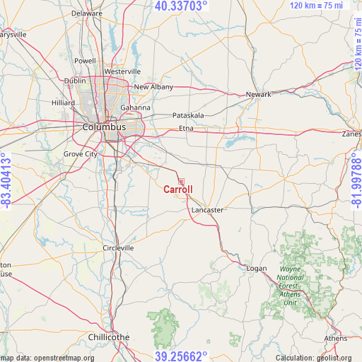
Carroll GPS coordinates[2]
39° 47' 56.22" North, 82° 42' 3.6" West
| Map corner | latitude | longitude |
|---|---|---|
| Upper-left | 40.33703°, | -83.40413° |
| Center: | 39.79895°, | -82.701° |
| Lower-right: | 39.25662°, | -81.99788° |
| Map W x H: | 120.1×120.1 km | = 74.6×74.6mi |
| max Lat: | 71.29058° ⇑48.5% North |
| Carroll: | 39.79895° |
| min Lat: | ⇓51.5% South 19.06759° |
| min Long | Carroll | max Long |
| -171.73463° | -82.701° | -66.98998° |
| W 62.9%⇐ | ⇒37.1% E |
Elevation
Elevation of Carroll is 252 m = 827 ft, and this is 42.8 m = 140 ft below average elevation for this country.
| Max E: |
3189 m = 10463 ft | 37.2% |
| Avg. | 294.8 m = 967 ft | |
| Carroll | 252 m = 827 ft | |
Min E: |
-60 m = -197 ft | 62.8% |
See also: United States elevation on elevation.city.
Geographical zone
Carroll is located in North temperate zone (between Tropic of Cancer and the Arctic Circle). Distance of this Northern Tropic circle is 1819.3 km =1130.5 mi to South.| Distance of | km | miles | from Carroll |
|---|---|---|---|
| North Pole | 5581.8 | 3468.4 | to North |
| Arctic Circle | 2975.9 | 1849.1 | to North |
| Tropic Cancer | 1819.3 | 1130.5 | to South |
| Equator | 4425.2 | 2749.7 | to South |


Nearby cities:
15 places around Carroll: (largest is in red/bold)
• Amanda
17 km =10.6 mi,  192°
192°
• Baltimore
10 km =6.2 mi,  58°
58°
• Blacklick Estates
18.3 km =11.4 mi,  310°
310°
• Canal Winchester
10.1 km =6.3 mi,  298°
298°
• Etna
17.7 km =11 mi,  5°
5°
• Groveport
17.9 km =11.1 mi, 299°
• Kirkersville
20 km =12.4 mi,  26°
26°
• Lancaster
12.9 km =8 mi,  137°
137°
• Lithopolis
9 km =5.6 mi,  272°
272°
• Millersport
18.2 km =11.3 mi,  51°
51°
• Pataskala
22 km =13.7 mi, 5°
• Pickerington
10.5 km =6.5 mi,  334°
334°
• Pleasantville
15.3 km =9.5 mi,  85°
85°
• Reynoldsburg
19.8 km =12.3 mi, 331°
• Thurston
14 km =8.7 mi,  70°
70°
Sources, notices
• [Note1] Compared only with cities in United States existing in our database
• [Src1] Map data: © OpenStreetMap contributors (CC-BY-SA)
• [Src2] Other city data from geonames.org with taken over terms of usage.
• [Src3] Geographical zone / Annual Mean Temperature by Robert A. Rohde @ Wikipedia
