Gratis geodata
Gratis (Ohio) is a populated place; located in United States in America/New_York (GMT-4) time zone. With population of 859 people, there are 17293 cities with bigger population in this country. Compared to other cities in United States, 50.3% of cities are located further ↓South; 57.3% of cities are located further ←West and 66.6% of cities have lower elevation than Gratis. Note1


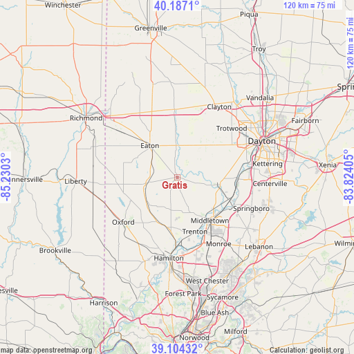
Gratis GPS coordinates[2]
39° 38' 52.188" North, 84° 31' 37.812" West
| Map corner | latitude | longitude |
|---|---|---|
| Upper-left | 40.1871°, | -85.2303° |
| Center: | 39.64783°, | -84.52717° |
| Lower-right: | 39.10432°, | -83.82405° |
| Map W x H: | 120.4×120.4 km | = 74.8×74.8mi |
| max Lat: | 71.29058° ⇑49.7% North |
| Gratis: | 39.64783° |
| min Lat: | ⇓50.3% South 19.06759° |
| min Long | Gratis | max Long |
| -171.73463° | -84.52717° | -66.98998° |
| W 57.3%⇐ | ⇒42.7% E |
Elevation
Elevation of Gratis is 269 m = 883 ft, and this is 25.8 m = 85 ft below average elevation for this country.
| Max E: |
3189 m = 10463 ft | 33.4% |
| Avg. | 294.8 m = 967 ft | |
| Gratis | 269 m = 883 ft | |
Min E: |
-60 m = -197 ft | 66.6% |
See also: United States elevation on elevation.city.
Geographical zone
Gratis is located in North temperate zone (between Tropic of Cancer and the Arctic Circle). Distance of this Northern Tropic circle is 1802.5 km =1120 mi to South.| Distance of | km | miles | from Gratis |
|---|---|---|---|
| North Pole | 5598.6 | 3478.8 | to North |
| Arctic Circle | 2992.7 | 1859.6 | to North |
| Tropic Cancer | 1802.5 | 1120 | to South |
| Equator | 4408.4 | 2739.3 | to South |


Nearby cities:
15 places around Gratis: (largest is in red/bold)
• Camden
10.6 km =6.6 mi,  258°
258°
• Carlisle
19.2 km =11.9 mi,  112°
112°
• Darrtown
20.5 km =12.7 mi,  214°
214°
• Eaton
14.2 km =8.8 mi,  318°
318°
• Farmersville
9.1 km =5.7 mi,  67°
67°
• Franklin
21.5 km =13.4 mi,  117°
117°
• Germantown
13.7 km =8.5 mi,  100°
100°
• Lake Lakengren
14.9 km =9.3 mi,  287°
287°
• Mayfield
21.6 km =13.4 mi,  142°
142°
• Miamisburg
20.6 km =12.8 mi,  91°
91°
• Middletown
18.4 km =11.4 mi, 143°
• New Lebanon
16.3 km =10.1 mi,  48°
48°
• Seven Mile
18.8 km =11.7 mi,  186°
186°
• Trenton
19.5 km =12.1 mi,  162°
162°
• West Alexandria
10.8 km =6.7 mi,  357°
357°
Sources, notices
• [Note1] Compared only with cities in United States existing in our database
• [Src1] Map data: © OpenStreetMap contributors (CC-BY-SA)
• [Src2] Other city data from geonames.org with taken over terms of usage.
• [Src3] Geographical zone / Annual Mean Temperature by Robert A. Rohde @ Wikipedia
