Trenton geodata
Trenton (Ohio) is a populated place; located in United States in America/New_York (GMT-4) time zone. With population of 12,281 people, there are 3828 cities with bigger population in this country. Compared to other cities in United States, 51% of cities are located further ↑North; 57.6% of cities are located further ←West and 50% of cities have lower elevation than Trenton. Note1


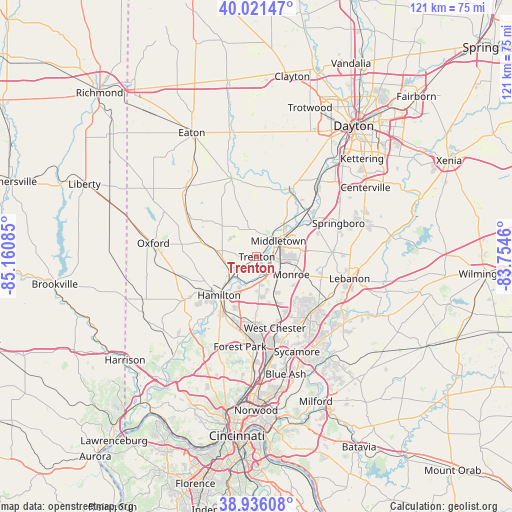
Trenton GPS coordinates[2]
39° 28' 51.204" North, 84° 27' 27.792" West
| Map corner | latitude | longitude |
|---|---|---|
| Upper-left | 40.02147°, | -85.16085° |
| Center: | 39.48089°, | -84.45772° |
| Lower-right: | 38.93608°, | -83.7546° |
| Map W x H: | 120.7×120.7 km | = 75×75mi |
| max Lat: | 71.29058° ⇑51% North |
| Trenton: | 39.48089° |
| min Lat: | ⇓49% South 19.06759° |
| min Long | Trenton | max Long |
| -171.73463° | -84.45772° | -66.98998° |
| W 57.6%⇐ | ⇒42.4% E |
Elevation
Elevation of Trenton is 198 m = 650 ft, and this is 96.8 m = 318 ft below average elevation for this country.
| Max E: |
3189 m = 10463 ft | 50% |
| Avg. | 294.8 m = 967 ft | |
| Trenton | 198 m = 650 ft | |
Min E: |
-60 m = -197 ft | 50% |
See also: United States elevation on elevation.city.
Geographical zone
Trenton is located in North temperate zone (between Tropic of Cancer and the Arctic Circle). Distance of this Northern Tropic circle is 1783.9 km =1108.5 mi to South.| Distance of | km | miles | from Trenton |
|---|---|---|---|
| North Pole | 5617.2 | 3490.4 | to North |
| Arctic Circle | 3011.3 | 1871.1 | to North |
| Tropic Cancer | 1783.9 | 1108.5 | to South |
| Equator | 4389.9 | 2727.8 | to South |


Nearby cities:
15 places around Trenton: (largest is in red/bold)
• Beckett Ridge
15 km =9.3 mi,  172°
172°
• Carlisle
16.3 km =10.1 mi,  46°
46°
• Darrtown
17.5 km =10.9 mi,  275°
275°
• Fairfield
17.4 km =10.8 mi,  210°
210°
• Franklin
15.8 km =9.8 mi,  56°
56°
• Germantown
17.8 km =11.1 mi,  25°
25°
• Hamilton
12.7 km =7.9 mi,  224°
224°
• Hunter
14.5 km =9 mi,  84°
84°
• Mayfield
7.5 km =4.7 mi, 78°
• Middletown
6.4 km =4 mi, 53°
• Monroe
9.4 km =5.8 mi,  118°
118°
• New Miami
8.5 km =5.3 mi,  232°
232°
• Seven Mile
8.1 km =5 mi,  269°
269°
• Wetherington
14.7 km =9.1 mi,  152°
152°
• Williamsdale
7.6 km =4.7 mi, 234°
Sources, notices
• [Note1] Compared only with cities in United States existing in our database
• [Src1] Map data: © OpenStreetMap contributors (CC-BY-SA)
• [Src2] Other city data from geonames.org with taken over terms of usage.
• [Src3] Geographical zone / Annual Mean Temperature by Robert A. Rohde @ Wikipedia
