Millville geodata
Millville (Ohio) is a populated place; located in United States in America/New_York (GMT-4) time zone. With population of 724 people, there are 18460 cities with bigger population in this country. Compared to other cities in United States, 51.7% of cities are located further ↑North; 56.8% of cities are located further ←West and 51.9% of cities have higher elevation than Millville. Note1


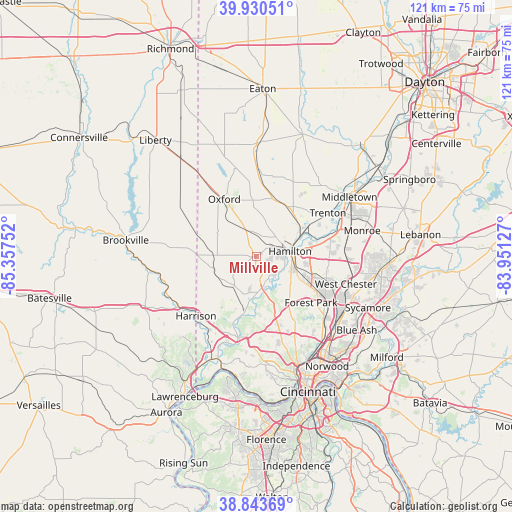
Millville GPS coordinates[2]
39° 23' 21.192" North, 84° 39' 15.804" West
| Map corner | latitude | longitude |
|---|---|---|
| Upper-left | 39.93051°, | -85.35752° |
| Center: | 39.38922°, | -84.65439° |
| Lower-right: | 38.84369°, | -83.95127° |
| Map W x H: | 120.8×120.8 km | = 75.1×75.1mi |
| max Lat: | 71.29058° ⇑51.7% North |
| Millville: | 39.38922° |
| min Lat: | ⇓48.3% South 19.06759° |
| min Long | Millville | max Long |
| -171.73463° | -84.65439° | -66.98998° |
| W 56.8%⇐ | ⇒43.2% E |
Elevation
Elevation of Millville is 191 m = 627 ft, and this is 103.8 m = 341 ft below average elevation for this country.
| Max E: |
3189 m = 10463 ft | 51.9% |
| Avg. | 294.8 m = 967 ft | |
| Millville | 191 m = 627 ft | |
Min E: |
-60 m = -197 ft | 48.1% |
See also: United States elevation on elevation.city.
Geographical zone
Millville is located in North temperate zone (between Tropic of Cancer and the Arctic Circle). Distance of this Northern Tropic circle is 1773.8 km =1102.2 mi to South.| Distance of | km | miles | from Millville |
|---|---|---|---|
| North Pole | 5627.4 | 3496.7 | to North |
| Arctic Circle | 3021.5 | 1877.5 | to North |
| Tropic Cancer | 1773.8 | 1102.2 | to South |
| Equator | 4379.7 | 2721.4 | to South |


Nearby cities:
15 places around Millville: (largest is in red/bold)
• Darrtown
11.8 km =7.3 mi,  357°
357°
• Dry Ridge
14.8 km =9.2 mi,  168°
168°
• Dunlap
11.2 km =7 mi,  163°
163°
• Fairfield
9.4 km =5.8 mi,  120°
120°
• Hamilton
8.1 km =5 mi,  81°
81°
• Mount Healthy Heights
15.2 km =9.4 mi,  150°
150°
• New Baltimore
13.9 km =8.6 mi,  184°
184°
• New Haven
14.7 km =9.1 mi,  210°
210°
• New Miami
11.3 km =7 mi,  63°
63°
• Oxford
15.2 km =9.4 mi,  329°
329°
• Pleasant Run
12.6 km =7.8 mi,  141°
141°
• Pleasant Run Farm
13.2 km =8.2 mi, 136°
• Ross
8.6 km =5.3 mi, 177°
• Seven Mile
13.4 km =8.3 mi,  41°
41°
• Williamsdale
12.2 km =7.6 mi, 61°
Sources, notices
• [Note1] Compared only with cities in United States existing in our database
• [Src1] Map data: © OpenStreetMap contributors (CC-BY-SA)
• [Src2] Other city data from geonames.org with taken over terms of usage.
• [Src3] Geographical zone / Annual Mean Temperature by Robert A. Rohde @ Wikipedia
