Mount Healthy Heights geodata
Mount Healthy Heights (Ohio) is a populated place; located in United States in America/New_York (GMT-4) time zone. With population of 3,264 people, there are 9205 cities with bigger population in this country. Compared to other cities in United States, 52.5% of cities are located further ↑North; 57.1% of cities are located further ←West and 64.5% of cities have lower elevation than Mount Healthy Heights. Note1
Current local time in Mount Healthy Heights:
02:51 PM, WednesdayDifference from your time zone: hours


Mount Healthy Heights GPS coordinates[2]
39° 16' 13.188" North, 84° 34' 4.8" West
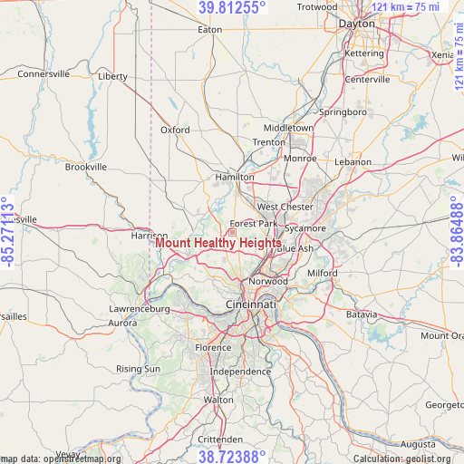
| Map corner | latitude | longitude |
|---|---|---|
| Upper-left | 39.81255°, | -85.27113° |
| Center: | 39.27033°, | -84.568° |
| Lower-right: | 38.72388°, | -83.86488° |
| Map W x H: | 121×121 km | = 75.2×75.2mi |
| max Lat: | 71.29058° ⇑52.5% North |
| Mount Healthy Heights: | 39.27033° |
| min Lat: | ⇓47.5% South 19.06759° |
| min Long | Mount Healthy H | max Long |
| -171.73463° | -84.568° | -66.98998° |
| W 57.1%⇐ | ⇒42.9% E |
Elevation
Elevation of Mount Healthy Heights is 260 m = 853 ft, and this is 34.8 m = 114 ft below average elevation for this country.
| Max E: |
3189 m = 10463 ft | 35.5% |
| Avg. | 294.8 m = 967 ft | |
| Mount Healthy Heights | 260 m = 853 ft | |
Min E: |
-60 m = -197 ft | 64.5% |
See also: United States elevation on elevation.city.
Geographical zone
Mount Healthy Heights is located in North temperate zone (between Tropic of Cancer and the Arctic Circle). Distance of this Northern Tropic circle is 1760.5 km =1093.9 mi to South.| Distance of | km | miles | from Mount Healthy Heights |
|---|---|---|---|
| North Pole | 5640.6 | 3504.9 | to North |
| Arctic Circle | 3034.7 | 1885.7 | to North |
| Tropic Cancer | 1760.5 | 1093.9 | to South |
| Equator | 4366.5 | 2713.2 | to South |


Nearby cities:
15 places around Mount Healthy Heights: (largest is in red/bold)
• Dry Ridge
4.6 km =2.9 mi,  254°
254°
• Dunlap
4.9 km =3 mi,  299°
299°
• Forest Park
5.9 km =3.7 mi,  67°
67°
• Greenhills
3.9 km =2.4 mi,  93°
93°
• Groesbeck
5.5 km =3.4 mi,  197°
197°
• Mount Healthy
4.5 km =2.8 mi,  154°
154°
• New Burlington
1.5 km =0.9 mi,  142°
142°
• North College Hill
6 km =3.7 mi,  165°
165°
• Northbrook
3 km =1.9 mi,  206°
206°
• Northgate
2.9 km =1.8 mi,  227°
227°
• Pleasant Hills
5.3 km =3.3 mi, 135°
• Pleasant Run
3.3 km =2.1 mi,  6°
6°
• Pleasant Run Farm
4 km =2.5 mi,  25°
25°
• Skyline Acres
4.6 km =2.9 mi,  178°
178°
• White Oak
6.9 km =4.3 mi, 203°
Sources, notices
• [Note1] Compared only with cities in United States existing in our database
• [Src1] Map data: © OpenStreetMap contributors (CC-BY-SA)
• [Src2] Other city data from geonames.org with taken over terms of usage.
• [Src3] Geographical zone / Annual Mean Temperature by Robert A. Rohde @ Wikipedia
