Mount Healthy geodata
Mount Healthy (Ohio) is a populated place; located in United States in America/New_York (GMT-4) time zone. With population of 6,039 people, there are 6372 cities with bigger population in this country. Compared to other cities in United States, 52.8% of cities are located further ↑North; 57.2% of cities are located further ←West and 64.3% of cities have lower elevation than Mount Healthy. Note1


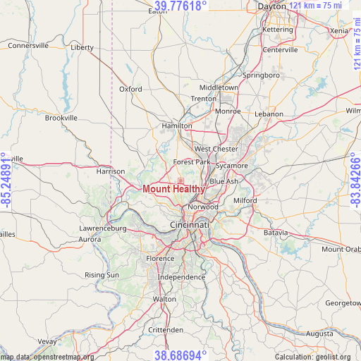
Mount Healthy GPS coordinates[2]
39° 14' 1.212" North, 84° 32' 44.808" West
| Map corner | latitude | longitude |
|---|---|---|
| Upper-left | 39.77618°, | -85.24891° |
| Center: | 39.23367°, | -84.54578° |
| Lower-right: | 38.68694°, | -83.84266° |
| Map W x H: | 121.1×121.1 km | = 75.2×75.2mi |
| max Lat: | 71.29058° ⇑52.8% North |
| Mount Healthy: | 39.23367° |
| min Lat: | ⇓47.2% South 19.06759° |
| min Long | Mount Healthy | max Long |
| -171.73463° | -84.54578° | -66.98998° |
| W 57.2%⇐ | ⇒42.8% E |
Elevation
Elevation of Mount Healthy is 259 m = 850 ft, and this is 35.8 m = 117 ft below average elevation for this country.
| Max E: |
3189 m = 10463 ft | 35.7% |
| Avg. | 294.8 m = 967 ft | |
| Mount Healthy | 259 m = 850 ft | |
Min E: |
-60 m = -197 ft | 64.3% |
See also: United States elevation on elevation.city.
Geographical zone
Mount Healthy is located in North temperate zone (between Tropic of Cancer and the Arctic Circle). Distance of this Northern Tropic circle is 1756.5 km =1091.4 mi to South.| Distance of | km | miles | from Mount Healthy |
|---|---|---|---|
| North Pole | 5644.7 | 3507.5 | to North |
| Arctic Circle | 3038.8 | 1888.2 | to North |
| Tropic Cancer | 1756.5 | 1091.4 | to South |
| Equator | 4362.4 | 2710.7 | to South |


Nearby cities:
15 places around Mount Healthy: (largest is in red/bold)
• Dry Ridge
6.9 km =4.3 mi,  294°
294°
• Finneytown
4.3 km =2.7 mi,  149°
149°
• Greenhills
4.3 km =2.7 mi,  27°
27°
• Groesbeck
3.7 km =2.3 mi,  251°
251°
• Monfort Heights
6.6 km =4.1 mi,  220°
220°
• Mount Healthy Heights
4.5 km =2.8 mi,  334°
334°
• New Burlington
3 km =1.9 mi,  341°
341°
• North College Hill
1.8 km =1.1 mi,  194°
194°
• Northbrook
3.6 km =2.2 mi, 293°
• Northgate
4.5 km =2.8 mi,  297°
297°
• Pleasant Hills
1.8 km =1.1 mi,  82°
82°
• Skyline Acres
1.9 km =1.2 mi, 252°
• White Oak
5.2 km =3.2 mi,  243°
243°
• Woodlawn
6.8 km =4.2 mi,  72°
72°
• Wyoming
6.9 km =4.3 mi,  92°
92°
Sources, notices
• [Note1] Compared only with cities in United States existing in our database
• [Src1] Map data: © OpenStreetMap contributors (CC-BY-SA)
• [Src2] Other city data from geonames.org with taken over terms of usage.
• [Src3] Geographical zone / Annual Mean Temperature by Robert A. Rohde @ Wikipedia
