Waynesville geodata
Waynesville (Ohio) is a populated place; located in United States in America/New_York (GMT-4) time zone. With population of 2,999 people, there are 9639 cities with bigger population in this country. Compared to other cities in United States, 50.7% of cities are located further ↑North; 59% of cities are located further ←West and 57.7% of cities have lower elevation than Waynesville. Note1


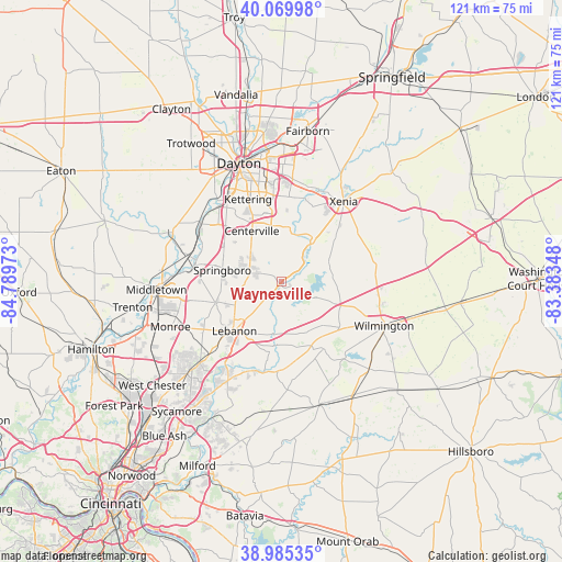
Waynesville GPS coordinates[2]
39° 31' 47.208" North, 84° 5' 11.76" West
| Map corner | latitude | longitude |
|---|---|---|
| Upper-left | 40.06998°, | -84.78973° |
| Center: | 39.52978°, | -84.0866° |
| Lower-right: | 38.98535°, | -83.38348° |
| Map W x H: | 120.6×120.6 km | = 74.9×74.9mi |
| max Lat: | 71.29058° ⇑50.7% North |
| Waynesville: | 39.52978° |
| min Lat: | ⇓49.3% South 19.06759° |
| min Long | Waynesville | max Long |
| -171.73463° | -84.0866° | -66.98998° |
| W 59%⇐ | ⇒41% E |
Elevation
Elevation of Waynesville is 229 m = 751 ft, and this is 65.8 m = 216 ft below average elevation for this country.
| Max E: |
3189 m = 10463 ft | 42.3% |
| Avg. | 294.8 m = 967 ft | |
| Waynesville | 229 m = 751 ft | |
Min E: |
-60 m = -197 ft | 57.7% |
See also: United States elevation on elevation.city.
Geographical zone
Waynesville is located in North temperate zone (between Tropic of Cancer and the Arctic Circle). Distance of this Northern Tropic circle is 1789.4 km =1111.9 mi to South.| Distance of | km | miles | from Waynesville |
|---|---|---|---|
| North Pole | 5611.8 | 3487 | to North |
| Arctic Circle | 3005.9 | 1867.8 | to North |
| Tropic Cancer | 1789.4 | 1111.9 | to South |
| Equator | 4395.3 | 2731.1 | to South |


Nearby cities:
15 places around Waynesville: (largest is in red/bold)
• Beavercreek
20.1 km =12.5 mi,  5°
5°
• Bellbrook
11.8 km =7.3 mi, 6°
• Carlisle
20.9 km =13 mi,  286°
286°
• Centerville
12.6 km =7.8 mi,  330°
330°
• Clarksville
16.9 km =10.5 mi,  147°
147°
• Five Points
10.1 km =6.3 mi,  295°
295°
• Franklin
18.9 km =11.7 mi,  279°
279°
• Harveysburg
7.1 km =4.4 mi,  113°
113°
• Hunter
17.9 km =11.1 mi,  256°
256°
• Kettering
19.1 km =11.9 mi,  338°
338°
• Lebanon
14.5 km =9 mi,  223°
223°
• Miamisburg
21.3 km =13.2 mi,  306°
306°
• Morrow
19.8 km =12.3 mi,  190°
190°
• South Lebanon
20.7 km =12.9 mi,  211°
211°
• Springboro
12.8 km =8 mi, 281°
Sources, notices
• [Note1] Compared only with cities in United States existing in our database
• [Src1] Map data: © OpenStreetMap contributors (CC-BY-SA)
• [Src2] Other city data from geonames.org with taken over terms of usage.
• [Src3] Geographical zone / Annual Mean Temperature by Robert A. Rohde @ Wikipedia
