Bethany geodata
Bethany (Oklahoma) is a populated place; located in United States in America/Chicago (GMT-5) time zone. With population of 19,589 people, there are 2562 cities with bigger population in this country. Compared to other cities in United States, 72.6% of cities are located further ↑North; 77.5% of cities are located further →East and 84% of cities have lower elevation than Bethany. Note1


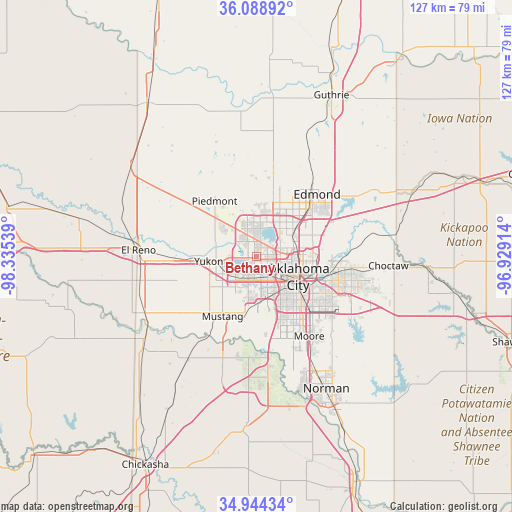
Bethany GPS coordinates[2]
35° 31' 7.212" North, 97° 37' 56.136" West
| Map corner | latitude | longitude |
|---|---|---|
| Upper-left | 36.08892°, | -98.33539° |
| Center: | 35.51867°, | -97.63226° |
| Lower-right: | 34.94434°, | -96.92914° |
| Map W x H: | 127.3×127.3 km | = 79.1×79.1mi |
| max Lat: | 71.29058° ⇑72.6% North |
| Bethany: | 35.51867° |
| min Lat: | ⇓27.4% South 19.06759° |
| min Long | Bethany | max Long |
| -171.73463° | -97.63226° | -66.98998° |
| W 22.5%⇐ | ⇒77.5% E |
Elevation
Elevation of Bethany is 404 m = 1325 ft, and this is 109.2 m = 358 ft above average elevation for this country.
| Max E: |
3189 m = 10463 ft | 16% |
| Bethany | 404 m 1325 ft | |
| Avg. | 294.8 m = 967 ft | |
Min E: |
-60 m = -197 ft | 84% |
See also: United States elevation on elevation.city.
Geographical zone
Bethany is located in North temperate zone (between Tropic of Cancer and the Arctic Circle). Distance of this Northern Tropic circle is 1343.4 km =834.7 mi to South.| Distance of | km | miles | from Bethany |
|---|---|---|---|
| North Pole | 6057.8 | 3764.1 | to North |
| Arctic Circle | 3451.9 | 2144.9 | to North |
| Tropic Cancer | 1343.4 | 834.7 | to South |
| Equator | 3949.3 | 2454 | to South |


Nearby cities:
15 places around Bethany: (largest is in red/bold)
• Del City
19.3 km =12 mi,  116°
116°
• Edmond
20.4 km =12.7 mi,  43°
43°
• Forest Park
16.9 km =10.5 mi,  95°
95°
• Midwest City
22.7 km =14.1 mi,  109°
109°
• Moore
23.9 km =14.9 mi,  146°
146°
• Mustang
17.1 km =10.6 mi,  209°
209°
• Nichols Hills
8.3 km =5.2 mi,  64°
64°
• Nicoma Park
28.2 km =17.5 mi, 96°
• Oklahoma City
11.9 km =7.4 mi, 118°
• Piedmont
17.2 km =10.7 mi,  323°
323°
• Spencer
23.1 km =14.4 mi,  88°
88°
• The Village
8.7 km =5.4 mi, 57°
• Valley Brook
18.8 km =11.7 mi,  133°
133°
• Warr Acres
1.3 km =0.8 mi,  70°
70°
• Yukon
11.9 km =7.4 mi,  263°
263°
Sources, notices
• [Note1] Compared only with cities in United States existing in our database
• [Src1] Map data: © OpenStreetMap contributors (CC-BY-SA)
• [Src2] Other city data from geonames.org with taken over terms of usage.
• [Src3] Geographical zone / Annual Mean Temperature by Robert A. Rohde @ Wikipedia
