Edmond geodata
Edmond (Oklahoma) is a populated place; located in United States in America/Chicago (GMT-5) time zone. With population of 90,092 people, there are 409 cities with bigger population in this country. Compared to other cities in United States, 71.9% of cities are located further ↑North; 77.1% of cities are located further →East and 81.6% of cities have lower elevation than Edmond. Note1


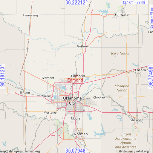
Edmond GPS coordinates[2]
35° 39' 10.188" North, 97° 28' 41.16" West
| Map corner | latitude | longitude |
|---|---|---|
| Upper-left | 36.22212°, | -98.18123° |
| Center: | 35.65283°, | -97.4781° |
| Lower-right: | 35.07946°, | -96.77498° |
| Map W x H: | 127.1×127.1 km | = 79×79mi |
| max Lat: | 71.29058° ⇑71.9% North |
| Edmond: | 35.65283° |
| min Lat: | ⇓28.1% South 19.06759° |
| min Long | Edmond | max Long |
| -171.73463° | -97.4781° | -66.98998° |
| W 22.9%⇐ | ⇒77.1% E |
Elevation
Elevation of Edmond is 372 m = 1220 ft, and this is 77.2 m = 253 ft above average elevation for this country.
| Max E: |
3189 m = 10463 ft | 18.4% |
| Edmond | 372 m 1220 ft | |
| Avg. | 294.8 m = 967 ft | |
Min E: |
-60 m = -197 ft | 81.6% |
See also: Edmond elevation on elevation.city.
Geographical zone
Edmond is located in North temperate zone (between Tropic of Cancer and the Arctic Circle). Distance of this Northern Tropic circle is 1358.3 km =844 mi to South.| Distance of | km | miles | from Edmond |
|---|---|---|---|
| North Pole | 6042.8 | 3754.8 | to North |
| Arctic Circle | 3437 | 2135.7 | to North |
| Tropic Cancer | 1358.3 | 844 | to South |
| Equator | 3964.2 | 2463.2 | to South |


Nearby cities:
15 places around Edmond: (largest is in red/bold)
• Bethany
20.4 km =12.7 mi,  223°
223°
• Cashion
24.3 km =15.1 mi,  311°
311°
• Del City
23.7 km =14.7 mi,  171°
171°
• Forest Park
16.8 km =10.4 mi, 170°
• Guthrie
25.6 km =15.9 mi,  10°
10°
• Jones
19.8 km =12.3 mi,  119°
119°
• Luther
25.5 km =15.8 mi,  87°
87°
• Midwest City
23.8 km =14.8 mi,  161°
161°
• Nichols Hills
13 km =8.1 mi,  209°
209°
• Nicoma Park
22.8 km =14.2 mi,  142°
142°
• Oklahoma City
20.9 km =13 mi,  189°
189°
• Piedmont
24.3 km =15.1 mi,  267°
267°
• Spencer
17.1 km =10.6 mi,  147°
147°
• The Village
12.2 km =7.6 mi, 212°
• Warr Acres
19.3 km =12 mi, 221°
Sources, notices
• [Note1] Compared only with cities in United States existing in our database
• [Src1] Map data: © OpenStreetMap contributors (CC-BY-SA)
• [Src2] Other city data from geonames.org with taken over terms of usage.
• [Src3] Geographical zone / Annual Mean Temperature by Robert A. Rohde @ Wikipedia
