Bray geodata
Bray (Oklahoma) is a populated place; located in United States in America/Chicago (GMT-5) time zone. With population of 1,193 people, there are 15161 cities with bigger population in this country. Compared to other cities in United States, 77.1% of cities are located further ↑North; 78.1% of cities are located further →East and 82.7% of cities have lower elevation than Bray. Note1


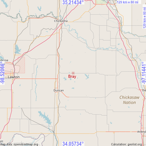
Bray GPS coordinates[2]
34° 38' 16.296" North, 97° 49' 3.108" West
| Map corner | latitude | longitude |
|---|---|---|
| Upper-left | 35.21434°, | -98.52066° |
| Center: | 34.63786°, | -97.81753° |
| Lower-right: | 34.05734°, | -97.11441° |
| Map W x H: | 128.6×128.6 km | = 79.9×79.9mi |
| max Lat: | 71.29058° ⇑77.1% North |
| Bray: | 34.63786° |
| min Lat: | ⇓22.9% South 19.06759° |
| min Long | Bray | max Long |
| -171.73463° | -97.81753° | -66.98998° |
| W 21.9%⇐ | ⇒78.1% E |
Elevation
Elevation of Bray is 386 m = 1266 ft, and this is 91.2 m = 299 ft above average elevation for this country.
| Max E: |
3189 m = 10463 ft | 17.3% |
| Bray | 386 m 1266 ft | |
| Avg. | 294.8 m = 967 ft | |
Min E: |
-60 m = -197 ft | 82.7% |
See also: United States elevation on elevation.city.
Geographical zone
Bray is located in North temperate zone (between Tropic of Cancer and the Arctic Circle). Distance of this Northern Tropic circle is 1245.5 km =773.9 mi to South.| Distance of | km | miles | from Bray |
|---|---|---|---|
| North Pole | 6155.7 | 3825 | to North |
| Arctic Circle | 3549.8 | 2205.7 | to North |
| Tropic Cancer | 1245.5 | 773.9 | to South |
| Equator | 3851.4 | 2393.1 | to South |


Nearby cities:
15 places around Bray: (largest is in red/bold)
• Alex
31 km =19.3 mi,  6°
6°
• Central High
25 km =15.5 mi,  266°
266°
• Comanche
32.8 km =20.4 mi,  204°
204°
• Duncan
19.8 km =12.3 mi,  220°
220°
• Elmore City
38.6 km =24 mi,  92°
92°
• Empire City
30.9 km =19.2 mi, 218°
• Lindsay
29.4 km =18.3 mi,  41°
41°
• Marlow
12.9 km =8 mi,  275°
275°
• Marlow
13.7 km =8.5 mi,  247°
247°
• Maysville
42.6 km =26.5 mi,  62°
62°
• Meridian
27.6 km =17.1 mi,  212°
212°
• Ninnekah
35.8 km =22.2 mi,  344°
344°
• Rush Springs
20.5 km =12.7 mi,  321°
321°
• Sterling
34.7 km =21.6 mi,  291°
291°
• Velma
23.7 km =14.7 mi,  146°
146°
Sources, notices
• [Note1] Compared only with cities in United States existing in our database
• [Src1] Map data: © OpenStreetMap contributors (CC-BY-SA)
• [Src2] Other city data from geonames.org with taken over terms of usage.
• [Src3] Geographical zone / Annual Mean Temperature by Robert A. Rohde @ Wikipedia
