Sterling geodata
Sterling (Oklahoma) is a populated place; located in United States in America/Chicago (GMT-5) time zone. With population of 803 people, there are 17786 cities with bigger population in this country. Compared to other cities in United States, 76.6% of cities are located further ↑North; 78.8% of cities are located further →East and 81.9% of cities have lower elevation than Sterling. Note1


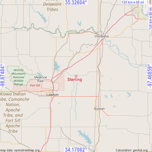
Sterling GPS coordinates[2]
34° 45' 1.26" North, 98° 10' 18.156" West
| Map corner | latitude | longitude |
|---|---|---|
| Upper-left | 35.32604°, | -98.87484° |
| Center: | 34.75035°, | -98.17171° |
| Lower-right: | 34.17062°, | -97.46859° |
| Map W x H: | 128.5×128.5 km | = 79.8×79.8mi |
| max Lat: | 71.29058° ⇑76.6% North |
| Sterling: | 34.75035° |
| min Lat: | ⇓23.4% South 19.06759° |
| min Long | Sterling | max Long |
| -171.73463° | -98.17171° | -66.98998° |
| W 21.2%⇐ | ⇒78.8% E |
Elevation
Elevation of Sterling is 375 m = 1230 ft, and this is 80.2 m = 263 ft above average elevation for this country.
| Max E: |
3189 m = 10463 ft | 18.1% |
| Sterling | 375 m 1230 ft | |
| Avg. | 294.8 m = 967 ft | |
Min E: |
-60 m = -197 ft | 81.9% |
See also: United States elevation on elevation.city.
Geographical zone
Sterling is located in North temperate zone (between Tropic of Cancer and the Arctic Circle). Distance of this Northern Tropic circle is 1258 km =781.7 mi to South.| Distance of | km | miles | from Sterling |
|---|---|---|---|
| North Pole | 6143.2 | 3817.2 | to North |
| Arctic Circle | 3537.3 | 2198 | to North |
| Tropic Cancer | 1258 | 781.7 | to South |
| Equator | 3863.9 | 2400.9 | to South |


Nearby cities:
15 places around Sterling: (largest is in red/bold)
• Anadarko
36.4 km =22.6 mi,  349°
349°
• Apache
23.8 km =14.8 mi,  311°
311°
• Bray
34.7 km =21.6 mi,  111°
111°
• Central High
16 km =9.9 mi,  152°
152°
• Cyril
16.5 km =10.3 mi, 350°
• Duncan
33.8 km =21 mi,  144°
144°
• Elgin
11.5 km =7.1 mi,  286°
286°
• Fletcher
10.5 km =6.5 mi,  320°
320°
• Geronimo
35.6 km =22.1 mi,  212°
212°
• Lawton
25.4 km =15.8 mi,  231°
231°
• Marlow
22.6 km =14 mi,  120°
120°
• Marlow
26.6 km =16.5 mi,  132°
132°
• Ninnekah
31.5 km =19.6 mi,  45°
45°
• Rush Springs
19.9 km =12.4 mi,  79°
79°
• Verden
37.8 km =23.5 mi,  11°
11°
Sources, notices
• [Note1] Compared only with cities in United States existing in our database
• [Src1] Map data: © OpenStreetMap contributors (CC-BY-SA)
• [Src2] Other city data from geonames.org with taken over terms of usage.
• [Src3] Geographical zone / Annual Mean Temperature by Robert A. Rohde @ Wikipedia
