Broken Bow geodata
Broken Bow (Oklahoma) is a populated place; located in United States in America/Chicago (GMT-5) time zone. With population of 4,131 people, there are 8066 cities with bigger population in this country. Compared to other cities in United States, 80% of cities are located further ↑North; 70.5% of cities are located further →East and 61.7% of cities have higher elevation than Broken Bow. Note1


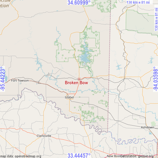
Broken Bow GPS coordinates[2]
34° 1' 45.408" North, 94° 44' 20.76" West
| Map corner | latitude | longitude |
|---|---|---|
| Upper-left | 34.60999°, | -95.44223° |
| Center: | 34.02928°, | -94.7391° |
| Lower-right: | 33.44457°, | -94.03598° |
| Map W x H: | 129.6×129.6 km | = 80.5×80.5mi |
| max Lat: | 71.29058° ⇑80% North |
| Broken Bow: | 34.02928° |
| min Lat: | ⇓20% South 19.06759° |
| min Long | Broken Bow | max Long |
| -171.73463° | -94.7391° | -66.98998° |
| W 29.5%⇐ | ⇒70.5% E |
Elevation
Elevation of Broken Bow is 146 m = 479 ft, and this is 148.8 m = 488 ft below average elevation for this country.
| Max E: |
3189 m = 10463 ft | 61.7% |
| Avg. | 294.8 m = 967 ft | |
| Broken Bow | 146 m = 479 ft | |
Min E: |
-60 m = -197 ft | 38.3% |
See also: United States elevation on elevation.city.
Geographical zone
Broken Bow is located in North temperate zone (between Tropic of Cancer and the Arctic Circle). Distance of this Northern Tropic circle is 1177.8 km =731.9 mi to South.| Distance of | km | miles | from Broken Bow |
|---|---|---|---|
| North Pole | 6223.4 | 3867 | to North |
| Arctic Circle | 3617.5 | 2247.8 | to North |
| Tropic Cancer | 1177.8 | 731.9 | to South |
| Equator | 3783.7 | 2351.1 | to South |


Nearby cities:
15 places around Broken Bow: (largest is in red/bold)
• Clarksville
54.8 km =34.1 mi,  211°
211°
• De Kalb
59 km =36.7 mi,  168°
168°
• De Queen
36.7 km =22.8 mi,  88°
88°
• Detroit
63.6 km =39.5 mi,  229°
229°
• Dierks
67.3 km =41.8 mi,  81°
81°
• Eagletown
15.1 km =9.4 mi, 87°
• Foreman
46.6 km =29 mi,  137°
137°
• Grannis
44 km =27.3 mi,  57°
57°
• Horatio
36.6 km =22.7 mi,  106°
106°
• Idabel
16.9 km =10.5 mi, 208°
• Lockesburg
53 km =32.9 mi,  97°
97°
• Lone Star
65.7 km =40.8 mi,  245°
245°
• Valliant
32.8 km =20.4 mi,  264°
264°
• Wickes
47.8 km =29.7 mi,  50°
50°
• Wright City
24.6 km =15.3 mi,  278°
278°
Sources, notices
• [Note1] Compared only with cities in United States existing in our database
• [Src1] Map data: © OpenStreetMap contributors (CC-BY-SA)
• [Src2] Other city data from geonames.org with taken over terms of usage.
• [Src3] Geographical zone / Annual Mean Temperature by Robert A. Rohde @ Wikipedia
