Wright City geodata
Wright City (Oklahoma) is a populated place; located in United States in America/Chicago (GMT-5) time zone. With population of 745 people, there are 18255 cities with bigger population in this country. Compared to other cities in United States, 79.8% of cities are located further ↑North; 71.1% of cities are located further →East and 66% of cities have higher elevation than Wright City. Note1


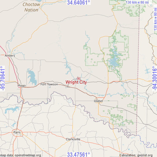
Wright City GPS coordinates[2]
34° 3' 36.396" North, 95° 0' 11.808" West
| Map corner | latitude | longitude |
|---|---|---|
| Upper-left | 34.64061°, | -95.70641° |
| Center: | 34.06011°, | -95.00328° |
| Lower-right: | 33.47561°, | -94.30016° |
| Map W x H: | 129.5×129.5 km | = 80.5×80.5mi |
| max Lat: | 71.29058° ⇑79.8% North |
| Wright City: | 34.06011° |
| min Lat: | ⇓20.2% South 19.06759° |
| min Long | Wright City | max Long |
| -171.73463° | -95.00328° | -66.98998° |
| W 28.9%⇐ | ⇒71.1% E |
Elevation
Elevation of Wright City is 123 m = 404 ft, and this is 171.8 m = 564 ft below average elevation for this country.
| Max E: |
3189 m = 10463 ft | 66% |
| Avg. | 294.8 m = 967 ft | |
| Wright City | 123 m = 404 ft | |
Min E: |
-60 m = -197 ft | 34% |
See also: United States elevation on elevation.city.
Geographical zone
Wright City is located in North temperate zone (between Tropic of Cancer and the Arctic Circle). Distance of this Northern Tropic circle is 1181.2 km =734 mi to South.| Distance of | km | miles | from Wright City |
|---|---|---|---|
| North Pole | 6219.9 | 3864.9 | to North |
| Arctic Circle | 3614 | 2245.6 | to North |
| Tropic Cancer | 1181.2 | 734 | to South |
| Equator | 3787.1 | 2353.2 | to South |


Nearby cities:
15 places around Wright City: (largest is in red/bold)
• Antlers
59.9 km =37.2 mi,  288°
288°
• Blossom
56.7 km =35.2 mi,  218°
218°
• Broken Bow
24.6 km =15.3 mi,  98°
98°
• Clarksville
50.2 km =31.2 mi,  185°
185°
• De Queen
61 km =37.9 mi,  92°
92°
• Detroit
50.6 km =31.4 mi,  208°
208°
• Eagletown
39.6 km =24.6 mi, 94°
• Grannis
64.7 km =40.2 mi,  71°
71°
• Horatio
61.1 km =38 mi, 102°
• Hugo
47 km =29.2 mi,  263°
263°
• Idabel
24.5 km =15.2 mi,  138°
138°
• Lone Star
46.8 km =29.1 mi,  229°
229°
• Powderly
55.5 km =34.5 mi,  240°
240°
• Reno
61.2 km =38 mi, 223°
• Valliant
10.5 km =6.5 mi, 232°
Sources, notices
• [Note1] Compared only with cities in United States existing in our database
• [Src1] Map data: © OpenStreetMap contributors (CC-BY-SA)
• [Src2] Other city data from geonames.org with taken over terms of usage.
• [Src3] Geographical zone / Annual Mean Temperature by Robert A. Rohde @ Wikipedia
