Geary geodata
Geary (Oklahoma) is a populated place; located in United States in America/Chicago (GMT-5) time zone. With population of 1,305 people, there are 14570 cities with bigger population in this country. Compared to other cities in United States, 72% of cities are located further ↑North; 79.1% of cities are located further →East and 87.2% of cities have lower elevation than Geary. Note1


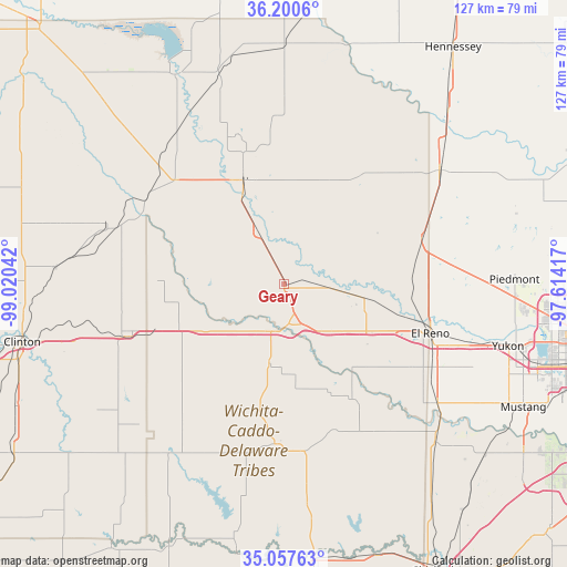
Geary GPS coordinates[2]
35° 37' 52.176" North, 98° 19' 2.244" West
| Map corner | latitude | longitude |
|---|---|---|
| Upper-left | 36.2006°, | -99.02042° |
| Center: | 35.63116°, | -98.31729° |
| Lower-right: | 35.05763°, | -97.61417° |
| Map W x H: | 127.1×127.1 km | = 79×79mi |
| max Lat: | 71.29058° ⇑72% North |
| Geary: | 35.63116° |
| min Lat: | ⇓28% South 19.06759° |
| min Long | Geary | max Long |
| -171.73463° | -98.31729° | -66.98998° |
| W 20.9%⇐ | ⇒79.1% E |
Elevation
Elevation of Geary is 474 m = 1555 ft, and this is 179.2 m = 588 ft above average elevation for this country.
| Max E: |
3189 m = 10463 ft | 12.8% |
| Geary | 474 m 1555 ft | |
| Avg. | 294.8 m = 967 ft | |
Min E: |
-60 m = -197 ft | 87.2% |
See also: United States elevation on elevation.city.
Geographical zone
Geary is located in North temperate zone (between Tropic of Cancer and the Arctic Circle). Distance of this Northern Tropic circle is 1355.9 km =842.5 mi to South.| Distance of | km | miles | from Geary |
|---|---|---|---|
| North Pole | 6045.2 | 3756.3 | to North |
| Arctic Circle | 3439.4 | 2137.1 | to North |
| Tropic Cancer | 1355.9 | 842.5 | to South |
| Equator | 3961.8 | 2461.7 | to South |


Nearby cities:
15 places around Geary: (largest is in red/bold)
• Binger
35.9 km =22.3 mi,  183°
183°
• Calumet
18.3 km =11.4 mi,  100°
100°
• Corn
50.6 km =31.4 mi,  236°
236°
• El Reno
34.6 km =21.5 mi,  108°
108°
• Hinton
18.1 km =11.2 mi,  191°
191°
• Hydro
25.3 km =15.7 mi,  248°
248°
• Kingfisher
43.2 km =26.8 mi,  53°
53°
• Minco
48.9 km =30.4 mi,  136°
136°
• Okarche
32.5 km =20.2 mi,  71°
71°
• Piedmont
51.6 km =32.1 mi,  88°
88°
• Thomas
40.8 km =25.4 mi,  287°
287°
• Union City
43.2 km =26.8 mi,  128°
128°
• Watonga
25.3 km =15.7 mi,  339°
339°
• Weatherford
37.2 km =23.1 mi, 251°
• Yukon
52 km =32.3 mi, 105°
Sources, notices
• [Note1] Compared only with cities in United States existing in our database
• [Src1] Map data: © OpenStreetMap contributors (CC-BY-SA)
• [Src2] Other city data from geonames.org with taken over terms of usage.
• [Src3] Geographical zone / Annual Mean Temperature by Robert A. Rohde @ Wikipedia
