Okarche geodata
Okarche (Oklahoma) is a populated place; located in United States in America/Chicago (GMT-5) time zone. With population of 1,307 people, there are 14564 cities with bigger population in this country. Compared to other cities in United States, 71.7% of cities are located further ↑North; 78.4% of cities are located further →East and 82.4% of cities have lower elevation than Okarche. Note1


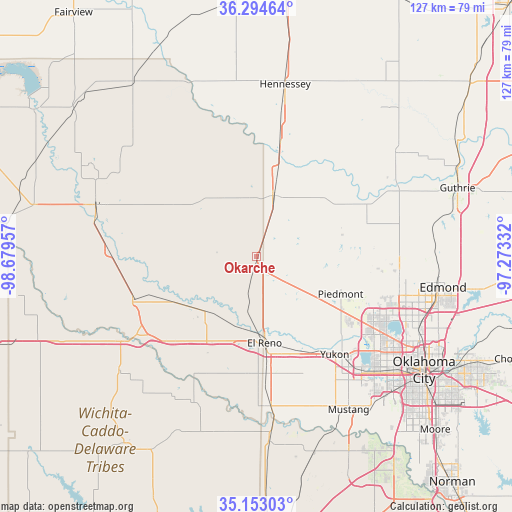
Okarche GPS coordinates[2]
35° 43' 33.168" North, 97° 58' 35.184" West
| Map corner | latitude | longitude |
|---|---|---|
| Upper-left | 36.29464°, | -98.67957° |
| Center: | 35.72588°, | -97.97644° |
| Lower-right: | 35.15303°, | -97.27332° |
| Map W x H: | 126.9×126.9 km | = 78.9×78.9mi |
| max Lat: | 71.29058° ⇑71.7% North |
| Okarche: | 35.72588° |
| min Lat: | ⇓28.3% South 19.06759° |
| min Long | Okarche | max Long |
| -171.73463° | -97.97644° | -66.98998° |
| W 21.6%⇐ | ⇒78.4% E |
Elevation
Elevation of Okarche is 381 m = 1250 ft, and this is 86.2 m = 283 ft above average elevation for this country.
| Max E: |
3189 m = 10463 ft | 17.6% |
| Okarche | 381 m 1250 ft | |
| Avg. | 294.8 m = 967 ft | |
Min E: |
-60 m = -197 ft | 82.4% |
See also: United States elevation on elevation.city.
Geographical zone
Okarche is located in North temperate zone (between Tropic of Cancer and the Arctic Circle). Distance of this Northern Tropic circle is 1366.4 km =849 mi to South.| Distance of | km | miles | from Okarche |
|---|---|---|---|
| North Pole | 6034.7 | 3749.8 | to North |
| Arctic Circle | 3428.8 | 2130.6 | to North |
| Tropic Cancer | 1366.4 | 849 | to South |
| Equator | 3972.3 | 2468.3 | to South |


Nearby cities:
15 places around Okarche: (largest is in red/bold)
• Bethany
38.7 km =24 mi,  126°
126°
• Calumet
18.9 km =11.7 mi,  222°
222°
• Cashion
28 km =17.4 mi,  73°
73°
• Crescent
42.6 km =26.5 mi,  53°
53°
• El Reno
21.6 km =13.4 mi,  174°
174°
• Geary
32.5 km =20.2 mi,  251°
251°
• Hennessey
43.2 km =26.8 mi,  9°
9°
• Kingfisher
15.6 km =9.7 mi, 14°
• Nichols Hills
43.3 km =26.9 mi,  116°
116°
• Piedmont
22.8 km =14.2 mi,  114°
114°
• The Village
42.6 km =26.5 mi, 115°
• Union City
37.3 km =23.2 mi,  175°
175°
• Warr Acres
39.4 km =24.5 mi, 124°
• Watonga
41.5 km =25.8 mi,  288°
288°
• Yukon
31.1 km =19.3 mi,  141°
141°
Sources, notices
• [Note1] Compared only with cities in United States existing in our database
• [Src1] Map data: © OpenStreetMap contributors (CC-BY-SA)
• [Src2] Other city data from geonames.org with taken over terms of usage.
• [Src3] Geographical zone / Annual Mean Temperature by Robert A. Rohde @ Wikipedia
