Hulbert geodata
Hulbert (Oklahoma) is a populated place; located in United States in America/Chicago (GMT-5) time zone. With population of 603 people, there are 19664 cities with bigger population in this country. Compared to other cities in United States, 70.7% of cities are located further ↑North; 71.5% of cities are located further →East and 50.8% of cities have higher elevation than Hulbert. Note1


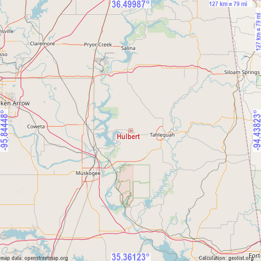
Hulbert GPS coordinates[2]
35° 55' 57.36" North, 95° 8' 28.86" West
| Map corner | latitude | longitude |
|---|---|---|
| Upper-left | 36.49987°, | -95.84448° |
| Center: | 35.9326°, | -95.14135° |
| Lower-right: | 35.36123°, | -94.43823° |
| Map W x H: | 126.6×126.6 km | = 78.7×78.7mi |
| max Lat: | 71.29058° ⇑70.7% North |
| Hulbert: | 35.9326° |
| min Lat: | ⇓29.3% South 19.06759° |
| min Long | Hulbert | max Long |
| -171.73463° | -95.14135° | -66.98998° |
| W 28.5%⇐ | ⇒71.5% E |
Elevation
Elevation of Hulbert is 195 m = 640 ft, and this is 99.8 m = 327 ft below average elevation for this country.
| Max E: |
3189 m = 10463 ft | 50.8% |
| Avg. | 294.8 m = 967 ft | |
| Hulbert | 195 m = 640 ft | |
Min E: |
-60 m = -197 ft | 49.2% |
See also: United States elevation on elevation.city.
Geographical zone
Hulbert is located in North temperate zone (between Tropic of Cancer and the Arctic Circle). Distance of this Northern Tropic circle is 1389.4 km =863.3 mi to South.| Distance of | km | miles | from Hulbert |
|---|---|---|---|
| North Pole | 6011.7 | 3735.5 | to North |
| Arctic Circle | 3405.8 | 2116.3 | to North |
| Tropic Cancer | 1389.4 | 863.3 | to South |
| Equator | 3995.3 | 2482.6 | to South |


Nearby cities:
15 places around Hulbert: (largest is in red/bold)
• Fort Gibson
17.9 km =11.1 mi,  213°
213°
• Keys
21.6 km =13.4 mi,  133°
133°
• Locust Grove
29.8 km =18.5 mi,  355°
355°
• Lost City
6.2 km =3.9 mi,  4°
4°
• Muskogee
29.1 km =18.1 mi,  225°
225°
• Okay
18.4 km =11.4 mi,  240°
240°
• Park Hill
18.3 km =11.4 mi,  115°
115°
• Peggs
16.9 km =10.5 mi,  12°
12°
• Pettit
24.5 km =15.2 mi,  139°
139°
• Shady Grove
4.4 km =2.7 mi,  72°
72°
• Tahlequah
15.6 km =9.7 mi,  97°
97°
• Tenkiller
29 km =18 mi, 120°
• Wagoner
20.7 km =12.9 mi,  278°
278°
• Welling
22.5 km =14 mi,  105°
105°
• Woodall
12.7 km =7.9 mi,  148°
148°
Sources, notices
• [Note1] Compared only with cities in United States existing in our database
• [Src1] Map data: © OpenStreetMap contributors (CC-BY-SA)
• [Src2] Other city data from geonames.org with taken over terms of usage.
• [Src3] Geographical zone / Annual Mean Temperature by Robert A. Rohde @ Wikipedia
