Sand Springs geodata
Sand Springs (Oklahoma) is a populated place; located in United States in America/Chicago (GMT-5) time zone. With population of 19,783 people, there are 2546 cities with bigger population in this country. Compared to other cities in United States, 69.7% of cities are located further ↑North; 73.6% of cities are located further →East and 53.5% of cities have lower elevation than Sand Springs. Note1


Sand Springs GPS coordinates[2]
36° 8' 23.316" North, 96° 6' 32.004" West
| Map corner | latitude | longitude |
|---|---|---|
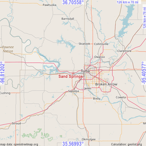
| Upper-left | 36.70558°, | -96.81202° |
| Center: | 36.13981°, | -96.10889° |
| Lower-right: | 35.56993°, | -95.40577° |
| Map W x H: | 126.3×126.3 km | = 78.5×78.5mi |
| max Lat: | 71.29058° ⇑69.7% North |
| Sand Springs: | 36.13981° |
| min Lat: | ⇓30.3% South 19.06759° |
| min Long | Sand Springs | max Long |
| -171.73463° | -96.10889° | -66.98998° |
| W 26.4%⇐ | ⇒73.6% E |
Elevation
Elevation of Sand Springs is 212 m = 696 ft, and this is 82.8 m = 272 ft below average elevation for this country.
| Max E: |
3189 m = 10463 ft | 46.5% |
| Avg. | 294.8 m = 967 ft | |
| Sand Springs | 212 m = 696 ft | |
Min E: |
-60 m = -197 ft | 53.5% |
See also: United States elevation on elevation.city.
Geographical zone
Sand Springs is located in North temperate zone (between Tropic of Cancer and the Arctic Circle). Distance of this Northern Tropic circle is 1412.5 km =877.7 mi to South.| Distance of | km | miles | from Sand Springs |
|---|---|---|---|
| North Pole | 5988.7 | 3721.2 | to North |
| Arctic Circle | 3382.8 | 2102 | to North |
| Tropic Cancer | 1412.5 | 877.7 | to South |
| Equator | 4018.4 | 2496.9 | to South |


Nearby cities:
15 places around Sand Springs: (largest is in red/bold)
• Bixby
29.9 km =18.6 mi,  137°
137°
• Broken Arrow
30.2 km =18.8 mi,  108°
108°
• Glenpool
22.4 km =13.9 mi,  156°
156°
• Jenks
18.1 km =11.2 mi, 135°
• Kellyville
23.8 km =14.8 mi,  203°
203°
• Kiefer
22 km =13.7 mi,  169°
169°
• Mannford
22.1 km =13.7 mi,  268°
268°
• Mounds
29.6 km =18.4 mi, 171°
• Oakhurst
8.2 km =5.1 mi,  150°
150°
• Owasso
27 km =16.8 mi,  57°
57°
• Sapulpa
15.7 km =9.8 mi,  181°
181°
• Skiatook
27.2 km =16.9 mi,  20°
20°
• Sperry
20.4 km =12.7 mi,  31°
31°
• Tulsa
10.5 km =6.5 mi,  81°
81°
• Turley
16.5 km =10.3 mi,  46°
46°
Sources, notices
• [Note1] Compared only with cities in United States existing in our database
• [Src1] Map data: © OpenStreetMap contributors (CC-BY-SA)
• [Src2] Other city data from geonames.org with taken over terms of usage.
• [Src3] Geographical zone / Annual Mean Temperature by Robert A. Rohde @ Wikipedia
