Tulsa geodata
Tulsa (Oklahoma) is a seat of a second-order administrative division; located in United States in America/Chicago (GMT-5) time zone. With population of 403,505 people, there are 52 cities with bigger population in this country. Compared to other cities in United States, 69.6% of cities are located further ↑North; 73.4% of cities are located further →East and 56.9% of cities have lower elevation than Tulsa. Note1


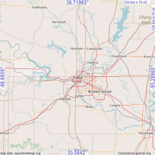
Tulsa GPS coordinates[2]
36° 9' 14.328" North, 95° 59' 33.972" West
| Map corner | latitude | longitude |
|---|---|---|
| Upper-left | 36.71965°, | -96.6959° |
| Center: | 36.15398°, | -95.99277° |
| Lower-right: | 35.5842°, | -95.28965° |
| Map W x H: | 126.3×126.2 km | = 78.5×78.4mi |
| max Lat: | 71.29058° ⇑69.6% North |
| Tulsa: | 36.15398° |
| min Lat: | ⇓30.4% South 19.06759° |
| min Long | Tulsa | max Long |
| -171.73463° | -95.99277° | -66.98998° |
| W 26.6%⇐ | ⇒73.4% E |
Elevation
Elevation of Tulsa is 226 m = 741 ft, and this is 68.8 m = 226 ft below average elevation for this country.
| Max E: |
3189 m = 10463 ft | 43.1% |
| Avg. | 294.8 m = 967 ft | |
| Tulsa | 226 m = 741 ft | |
Min E: |
-60 m = -197 ft | 56.9% |
See also: Tulsa elevation on elevation.city.
Geographical zone
Tulsa is located in North temperate zone (between Tropic of Cancer and the Arctic Circle). Distance of this Northern Tropic circle is 1414 km =878.6 mi to South.| Distance of | km | miles | from Tulsa |
|---|---|---|---|
| North Pole | 5987.1 | 3720.2 | to North |
| Arctic Circle | 3381.2 | 2101 | to North |
| Tropic Cancer | 1414 | 878.6 | to South |
| Equator | 4019.9 | 2497.8 | to South |


Nearby cities:
15 places around Tulsa: (largest is in red/bold)
• Bixby
25.5 km =15.8 mi,  157°
157°
• Broken Arrow
21.4 km =13.3 mi,  121°
121°
• Catoosa
22.5 km =14 mi,  80°
80°
• Collinsville
27.2 km =16.9 mi,  30°
30°
• Glenpool
22.1 km =13.7 mi,  183°
183°
• Jenks
14.7 km =9.1 mi,  171°
171°
• Kiefer
24.2 km =15 mi,  195°
195°
• Limestone
28.3 km =17.6 mi,  50°
50°
• Oakhurst
10.9 km =6.8 mi,  216°
216°
• Owasso
17.8 km =11.1 mi,  43°
43°
• Sand Springs
10.5 km =6.5 mi,  261°
261°
• Sapulpa
20.4 km =12.7 mi,  212°
212°
• Skiatook
23.9 km =14.9 mi,  358°
358°
• Sperry
15.9 km =9.9 mi,  0°
0°
• Turley
9.9 km =6.2 mi,  8°
8°
Sources, notices
• [Note1] Compared only with cities in United States existing in our database
• [Src1] Map data: © OpenStreetMap contributors (CC-BY-SA)
• [Src2] Other city data from geonames.org with taken over terms of usage.
• [Src3] Geographical zone / Annual Mean Temperature by Robert A. Rohde @ Wikipedia
