West Chester geodata
West Chester (Pennsylvania) is a seat of a second-order administrative division; located in United States in America/New_York (GMT-4) time zone. With population of 19,842 people, there are 2538 cities with bigger population in this country. Compared to other cities in United States, 53.2% of cities are located further ↓South; 85.3% of cities are located further ←West and 63.5% of cities have higher elevation than West Chester. Note1
Administrative division(s):
- Level 1: Pennsylvania
- Level 2: Chester County
- Level 3: Borough of West Chester


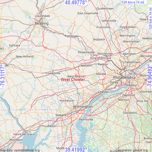
West Chester GPS coordinates[2]
39° 57' 39.492" North, 75° 36' 28.944" West
| Map corner | latitude | longitude |
|---|---|---|
| Upper-left | 40.49778°, | -76.31117° |
| Center: | 39.96097°, | -75.60804° |
| Lower-right: | 39.41992°, | -74.90492° |
| Map W x H: | 119.8×119.8 km | = 74.4×74.4mi |
| max Lat: | 71.29058° ⇑46.8% North |
| West Chester: | 39.96097° |
| min Lat: | ⇓53.2% South 19.06759° |
| min Long | West Chester | max Long |
| -171.73463° | -75.60804° | -66.98998° |
| W 85.3%⇐ | ⇒14.7% E |
Elevation
Elevation of West Chester is 136 m = 446 ft, and this is 158.8 m = 521 ft below average elevation for this country.
| Max E: |
3189 m = 10463 ft | 63.5% |
| Avg. | 294.8 m = 967 ft | |
| West Chester | 136 m = 446 ft | |
Min E: |
-60 m = -197 ft | 36.5% |
See also: United States elevation on elevation.city.
Geographical zone
West Chester is located in North temperate zone (between Tropic of Cancer and the Arctic Circle). Distance of this Northern Tropic circle is 1837.3 km =1141.6 mi to South.| Distance of | km | miles | from West Chester |
|---|---|---|---|
| North Pole | 5563.8 | 3457.2 | to North |
| Arctic Circle | 2957.9 | 1838 | to North |
| Tropic Cancer | 1837.3 | 1141.6 | to South |
| Equator | 4443.2 | 2760.9 | to South |


Nearby cities:
15 places around West Chester: (largest is in red/bold)
• Berwyn
17.2 km =10.7 mi,  57°
57°
• Caln
15 km =9.3 mi,  282°
282°
• Chester Heights
13.8 km =8.6 mi,  124°
124°
• Chester Springs
14.9 km =9.3 mi,  357°
357°
• Downingtown
9.6 km =6 mi,  301°
301°
• Eagleview
12.6 km =7.8 mi,  330°
330°
• Exton
7.6 km =4.7 mi,  351°
351°
• Kennett Square
15.5 km =9.6 mi,  214°
214°
• Lima
15.1 km =9.4 mi,  108°
108°
• Lionville
11.2 km =7 mi,  336°
336°
• Malvern
11.6 km =7.2 mi,  43°
43°
• Modena
16.4 km =10.2 mi,  270°
270°
• Paoli
14.4 km =8.9 mi,  51°
51°
• Thorndale
12.2 km =7.6 mi,  286°
286°
• Upland
16.4 km =10.2 mi,  239°
239°
Sources, notices
• [Note1] Compared only with cities in United States existing in our database
• [Src1] Map data: © OpenStreetMap contributors (CC-BY-SA)
• [Src2] Other city data from geonames.org with taken over terms of usage.
• [Src3] Geographical zone / Annual Mean Temperature by Robert A. Rohde @ Wikipedia
