Bowman geodata
Bowman (South Carolina) is a populated place; located in United States in America/New_York (GMT-4) time zone. With population of 934 people, there are 16762 cities with bigger population in this country. Compared to other cities in United States, 83.8% of cities are located further ↑North; 70.3% of cities are located further ←West and 80.6% of cities have higher elevation than Bowman. Note1


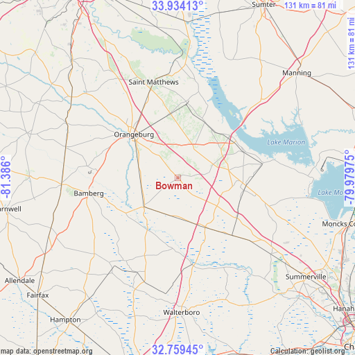
Bowman GPS coordinates[2]
33° 20' 55.572" North, 80° 40' 58.332" West
| Map corner | latitude | longitude |
|---|---|---|
| Upper-left | 33.93413°, | -81.386° |
| Center: | 33.34877°, | -80.68287° |
| Lower-right: | 32.75945°, | -79.97975° |
| Map W x H: | 130.6×130.6 km | = 81.2×81.2mi |
| max Lat: | 71.29058° ⇑83.8% North |
| Bowman: | 33.34877° |
| min Lat: | ⇓16.2% South 19.06759° |
| min Long | Bowman | max Long |
| -171.73463° | -80.68287° | -66.98998° |
| W 70.3%⇐ | ⇒29.7% E |
Elevation
Elevation of Bowman is 44 m = 144 ft, and this is 250.8 m = 823 ft below average elevation for this country.
| Max E: |
3189 m = 10463 ft | 80.6% |
| Avg. | 294.8 m = 967 ft | |
| Bowman | 44 m = 144 ft | |
Min E: |
-60 m = -197 ft | 19.4% |
See also: United States elevation on elevation.city.
Geographical zone
Bowman is located in North temperate zone (between Tropic of Cancer and the Arctic Circle). Distance of this Northern Tropic circle is 1102.1 km =684.8 mi to South.| Distance of | km | miles | from Bowman |
|---|---|---|---|
| North Pole | 6299 | 3914 | to North |
| Arctic Circle | 3693.1 | 2294.8 | to North |
| Tropic Cancer | 1102.1 | 684.8 | to South |
| Equator | 3708 | 2304 | to South |


Nearby cities:
15 places around Bowman: (largest is in red/bold)
• Bamberg
33.2 km =20.6 mi,  260°
260°
• Branchville
16.4 km =10.2 mi,  228°
228°
• Brookdale
21.9 km =13.6 mi,  323°
323°
• Denmark
42.8 km =26.6 mi,  266°
266°
• Edisto
24.6 km =15.3 mi,  305°
305°
• Ehrhardt
41.7 km =25.9 mi, 227°
• Elloree
22.7 km =14.1 mi,  26°
26°
• Harleyville
26.5 km =16.5 mi,  124°
124°
• Holly Hill
25.2 km =15.7 mi,  96°
96°
• Orangeburg
22.6 km =14 mi, 314°
• Saint George
20.7 km =12.9 mi,  151°
151°
• Saint Matthews
36.2 km =22.5 mi,  345°
345°
• Santee
23 km =14.3 mi,  52°
52°
• Summerton
42.2 km =26.2 mi, 46°
• Wilkinson Heights
22 km =13.7 mi, 320°
Sources, notices
• [Note1] Compared only with cities in United States existing in our database
• [Src1] Map data: © OpenStreetMap contributors (CC-BY-SA)
• [Src2] Other city data from geonames.org with taken over terms of usage.
• [Src3] Geographical zone / Annual Mean Temperature by Robert A. Rohde @ Wikipedia
