Harleyville geodata
Harleyville (South Carolina) is a populated place; located in United States in America/New_York (GMT-4) time zone. With population of 694 people, there are 18733 cities with bigger population in this country. Compared to other cities in United States, 84.3% of cities are located further ↑North; 71% of cities are located further ←West and 85.8% of cities have higher elevation than Harleyville. Note1


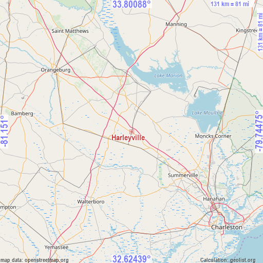
Harleyville GPS coordinates[2]
33° 12' 52.596" North, 80° 26' 52.332" West
| Map corner | latitude | longitude |
|---|---|---|
| Upper-left | 33.80088°, | -81.151° |
| Center: | 33.21461°, | -80.44787° |
| Lower-right: | 32.62439°, | -79.74475° |
| Map W x H: | 130.8×130.8 km | = 81.3×81.3mi |
| max Lat: | 71.29058° ⇑84.3% North |
| Harleyville: | 33.21461° |
| min Lat: | ⇓15.7% South 19.06759° |
| min Long | Harleyville | max Long |
| -171.73463° | -80.44787° | -66.98998° |
| W 71%⇐ | ⇒29% E |
Elevation
Elevation of Harleyville is 26 m = 85 ft, and this is 268.8 m = 882 ft below average elevation for this country.
| Max E: |
3189 m = 10463 ft | 85.8% |
| Avg. | 294.8 m = 967 ft | |
| Harleyville | 26 m = 85 ft | |
Min E: |
-60 m = -197 ft | 14.2% |
See also: United States elevation on elevation.city.
Geographical zone
Harleyville is located in North temperate zone (between Tropic of Cancer and the Arctic Circle). Distance of this Northern Tropic circle is 1087.2 km =675.6 mi to South.| Distance of | km | miles | from Harleyville |
|---|---|---|---|
| North Pole | 6313.9 | 3923.3 | to North |
| Arctic Circle | 3708.1 | 2304.1 | to North |
| Tropic Cancer | 1087.2 | 675.6 | to South |
| Equator | 3693.1 | 2294.8 | to South |


Nearby cities:
15 places around Harleyville: (largest is in red/bold)
• Bowman
26.5 km =16.5 mi,  304°
304°
• Branchville
34.4 km =21.4 mi,  276°
276°
• Centerville
35.5 km =22.1 mi,  133°
133°
• Cottageville
31 km =19.3 mi,  185°
185°
• Elloree
37 km =23 mi,  341°
341°
• Holly Hill
12.4 km =7.7 mi,  14°
14°
• Lincolnville
35.7 km =22.2 mi, 130°
• Moncks Corner
40.4 km =25.1 mi,  92°
92°
• Pinopolis
38.2 km =23.7 mi, 88°
• Ridgeville
18.1 km =11.2 mi,  136°
136°
• Saint George
12.3 km =7.6 mi,  255°
255°
• Sangaree
35.8 km =22.2 mi,  123°
123°
• Santee
29.2 km =18.1 mi,  352°
352°
• Summerville
33.4 km =20.8 mi, 130°
• Walterboro
40 km =24.9 mi,  210°
210°
Sources, notices
• [Note1] Compared only with cities in United States existing in our database
• [Src1] Map data: © OpenStreetMap contributors (CC-BY-SA)
• [Src2] Other city data from geonames.org with taken over terms of usage.
• [Src3] Geographical zone / Annual Mean Temperature by Robert A. Rohde @ Wikipedia
