Campobello geodata
Campobello (South Carolina) is a populated place; located in United States in America/New_York (GMT-4) time zone. With population of 526 people, there are 20560 cities with bigger population in this country. Compared to other cities in United States, 74.7% of cities are located further ↑North; 65% of cities are located further ←West and 68.2% of cities have lower elevation than Campobello. Note1


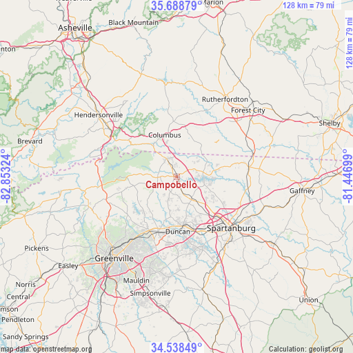
Campobello GPS coordinates[2]
35° 6' 56.412" North, 82° 9' 0.396" West
| Map corner | latitude | longitude |
|---|---|---|
| Upper-left | 35.68879°, | -82.85324° |
| Center: | 35.11567°, | -82.15011° |
| Lower-right: | 34.53849°, | -81.44699° |
| Map W x H: | 127.9×127.9 km | = 79.5×79.5mi |
| max Lat: | 71.29058° ⇑74.7% North |
| Campobello: | 35.11567° |
| min Lat: | ⇓25.3% South 19.06759° |
| min Long | Campobello | max Long |
| -171.73463° | -82.15011° | -66.98998° |
| W 65%⇐ | ⇒35% E |
Elevation
Elevation of Campobello is 277 m = 909 ft, and this is 17.8 m = 58 ft below average elevation for this country.
| Max E: |
3189 m = 10463 ft | 31.8% |
| Avg. | 294.8 m = 967 ft | |
| Campobello | 277 m = 909 ft | |
Min E: |
-60 m = -197 ft | 68.2% |
See also: United States elevation on elevation.city.
Geographical zone
Campobello is located in North temperate zone (between Tropic of Cancer and the Arctic Circle). Distance of this Northern Tropic circle is 1298.6 km =806.9 mi to South.| Distance of | km | miles | from Campobello |
|---|---|---|---|
| North Pole | 6102.6 | 3792 | to North |
| Arctic Circle | 3496.7 | 2172.7 | to North |
| Tropic Cancer | 1298.6 | 806.9 | to South |
| Equator | 3904.5 | 2426.1 | to South |


Nearby cities:
15 places around Campobello: (largest is in red/bold)
• Boiling Springs
17.1 km =10.6 mi,  116°
116°
• Columbus
15.9 km =9.9 mi,  344°
344°
• Duncan
19.8 km =12.3 mi,  178°
178°
• Fairforest
21.8 km =13.5 mi,  144°
144°
• Greer
20.9 km =13 mi,  199°
199°
• Inman
9.4 km =5.8 mi, 144°
• Inman Mills
9.2 km =5.7 mi,  153°
153°
• Landrum
7.5 km =4.7 mi,  331°
331°
• Lyman
18.7 km =11.6 mi,  173°
173°
• Southern Shops
20.2 km =12.6 mi, 135°
• Startex
21.3 km =13.2 mi, 167°
• Tigerville
20.5 km =12.7 mi,  255°
255°
• Tryon
13 km =8.1 mi,  322°
322°
• Valley Falls
19.4 km =12.1 mi, 124°
• Wellford
18.8 km =11.7 mi, 167°
Sources, notices
• [Note1] Compared only with cities in United States existing in our database
• [Src1] Map data: © OpenStreetMap contributors (CC-BY-SA)
• [Src2] Other city data from geonames.org with taken over terms of usage.
• [Src3] Geographical zone / Annual Mean Temperature by Robert A. Rohde @ Wikipedia
