Greer geodata
Greer (South Carolina) is a populated place; located in United States in America/New_York (GMT-4) time zone. With population of 28,365 people, there are 1754 cities with bigger population in this country. Compared to other cities in United States, 75.7% of cities are located further ↑North; 64.8% of cities are located further ←West and 74.9% of cities have lower elevation than Greer. Note1


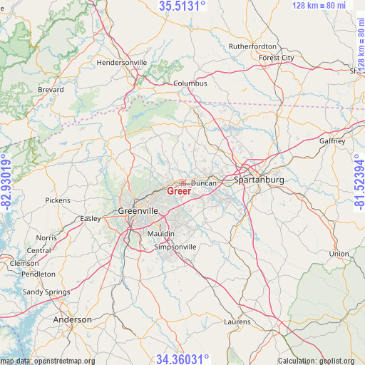
Greer GPS coordinates[2]
34° 56' 19.428" North, 82° 13' 37.416" West
| Map corner | latitude | longitude |
|---|---|---|
| Upper-left | 35.5131°, | -82.93019° |
| Center: | 34.93873°, | -82.22706° |
| Lower-right: | 34.36031°, | -81.52394° |
| Map W x H: | 128.2×128.2 km | = 79.7×79.7mi |
| max Lat: | 71.29058° ⇑75.7% North |
| Greer: | 34.93873° |
| min Lat: | ⇓24.3% South 19.06759° |
| min Long | Greer | max Long |
| -171.73463° | -82.22706° | -66.98998° |
| W 64.8%⇐ | ⇒35.2% E |
Elevation
Elevation of Greer is 312 m = 1024 ft, and this is 17.2 m = 56 ft above average elevation for this country.
| Max E: |
3189 m = 10463 ft | 25.1% |
| Greer | 312 m 1024 ft | |
| Avg. | 294.8 m = 967 ft | |
Min E: |
-60 m = -197 ft | 74.9% |
See also: United States elevation on elevation.city.
Geographical zone
Greer is located in North temperate zone (between Tropic of Cancer and the Arctic Circle). Distance of this Northern Tropic circle is 1278.9 km =794.7 mi to South.| Distance of | km | miles | from Greer |
|---|---|---|---|
| North Pole | 6122.2 | 3804.2 | to North |
| Arctic Circle | 3516.4 | 2185 | to North |
| Tropic Cancer | 1278.9 | 794.7 | to South |
| Equator | 3884.8 | 2413.9 | to South |


Nearby cities:
15 places around Greer: (largest is in red/bold)
• Duncan
7.5 km =4.7 mi,  90°
90°
• Fairforest
19.9 km =12.4 mi,  84°
84°
• Five Forks
14.9 km =9.3 mi,  180°
180°
• Greenville
18 km =11.2 mi,  237°
237°
• Inman
17.3 km =10.7 mi,  46°
46°
• Inman Mills
16 km =9.9 mi,  44°
44°
• Lyman
9.2 km =5.7 mi, 83°
• Mauldin
19.3 km =12 mi,  203°
203°
• Reidville
13.3 km =8.3 mi,  129°
129°
• Sans Souci
19.2 km =11.9 mi,  249°
249°
• Startex
11.7 km =7.3 mi,  95°
95°
• Taylors
6.6 km =4.1 mi, 252°
• Tigerville
19.3 km =12 mi,  318°
318°
• Wade Hampton
10.4 km =6.5 mi, 248°
• Wellford
11.1 km =6.9 mi, 82°
Sources, notices
• [Note1] Compared only with cities in United States existing in our database
• [Src1] Map data: © OpenStreetMap contributors (CC-BY-SA)
• [Src2] Other city data from geonames.org with taken over terms of usage.
• [Src3] Geographical zone / Annual Mean Temperature by Robert A. Rohde @ Wikipedia
